Testing the New Forecast Cone in 2024’s Unpredictable Hurricane Season
Published: August 27th, 2024
2024 Atlantic Hurricane Season, So Far
This year’s Atlantic hurricane season came to life with the help of a resilient overachiever. Between June 28th and 29th, a freshly formed tropical depression rapidly intensified into Hurricane Beryl, breaking its first of many records by becoming the easternmost Atlantic hurricane to form in June. Hurricane Beryl continued to rapidly intensify before it reached Category 4 status on the Saffir-Simpson scale, claiming its title as both the earliest and southernmost Category 4 hurricane to form in the Atlantic basin, just two days after its initial genesis. During its trek across the Caribbean Sea, the eye of hurricane Beryl made landfall in the small island of Carriacou on July 1st, with sustained winds of 150 mph. Beryl strengthened into a Category 5, also the earliest of its kind in the Atlantic Basin, shortly after departing the Grenadines and before striking the southeastern coast of Jamaica (1). The storm unexpectedly maintained major intensity despite moderate, ongoing wind shear, but weakened to a Category 2 as it approached its second landfall near Tulum, Mexico on the morning of July 5th. Beryl emerged over the heated Gulf of Mexico as a weakened tropical storm on a path toward a final landfall along the western Gulf. Beryl’s maritime journey concluded during the early morning hours of July 8th as its eye came ashore near Matagorda, Texas, after gathering just enough strength to briefly reclaim hurricane status. Maximum sustained winds of 80 mph were estimated at landfall (2), and preliminary wind gust reports in Brazoria County approached 100 mph (3).
Beryl left behind extensive damage and loss across the several nations it affected. A UN official in Carriacou described the island as “flattened” by Beryl’s extreme winds and destructive storm surge. With major roads left impassable, Carriacou now faces logistical obstacles to relief efforts. Residents of Jamaica were also hit hard by Beryl: incessant heavy rain caused widespread flooding, especially in the rural farming communities of the island’s southern region (4). In Texas, storm surge inundation was expected in the range of 4-7 feet from Mesquite Bay to Sabine Pass— total rainfall was forecast between 5-10 inches with localized areas up to 15 inches across the Texas Gulf Coast and into the eastern region of the state (2). The preliminary rainfall totals recorded by the National Weather Service (NWS) Houston/Galveston forecast office on Monday, July 8th shows that 14.88 inches of rain accumulated in Harris County near Hilshire Village. In Fort Bend County, Sugar Land received 13.32 inches of rain, while several more areas of this county (and others) received at least 10 inches (5). Further inland, Beryl continued to set records when the NWS office in Shreveport, Louisiana issued 67 tornado warnings on July 8th— the most in a single day that they had ever issued (6).
While Hurricane Beryl was approaching the Windward Islands on June 30th, a tropical depression quietly formed in the Gulf of Mexico to the west of the Yucatán Peninsula. The depression intensified as it moved westward, becoming Tropical Storm Chris shortly before making landfall in the state of Veracruz in eastern Mexico, at approximately 1 am local time, less than 12 hours after it formed. Although maximum sustained winds were only 40 mph, Chris brought heavy rain to the region, especially across higher terrain.
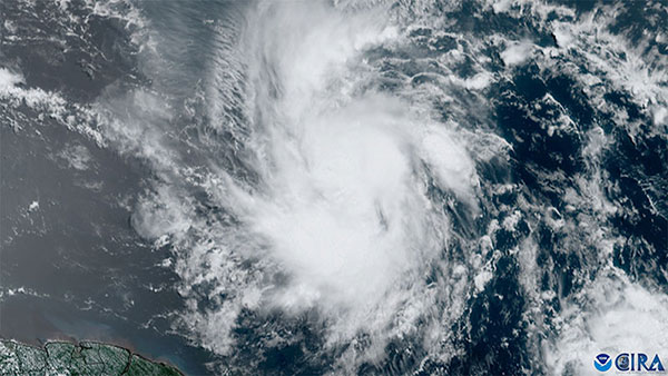
Several weeks of relative quiet followed Beryl’s landfall in Texas, but the tropical Atlantic reawakened in early August. At 11 am EST on August 2nd, the National Hurricane Center (NHC) initiated advisories for a tropical disturbance located over southeastern Cuba. By 5 pm on August 3rd, Tropical Storm Debby had formed while its center of circulation remained over land. Although further strengthening was expected when it reached a highly conducive environment in the Gulf of Mexico — which verified when Debby became a hurricane by 11pm on August 4th — tracking this tropical cyclone proved challenging: Debby’s broad and poorly-defined center in the days leading to its Florida landfall left greater uncertainty in the model guidance and forecast track. In addition to the track uncertainty, there was also significant uncertainty in the degree to which Debby would intensify prior to landfall over the record-warm Gulf waters. Such high uncertainty when the storm was so close to land and to landfall made preparations particularly challenging. Emergency officials, utilities, businesses, and individuals across the Southeast were left with little time to prepare for a wide range of potential outcomes. Once Debby’s center of circulation progressed to the northwest of Cuba, the storm began to consolidate and intensify, and the model guidance began to hone in on a landfall in Florida’s Big Bend region. After landfall, however, the models struggled to forecast Debby’s track. With very light atmospheric steering currents, Debby was forecasted to slow down and meander over northern Florida, southern Georgia, and the Carolinas for days, dumping massive amounts of rain as it continued to tap into the energy and moisture of the warm southern Atlantic.
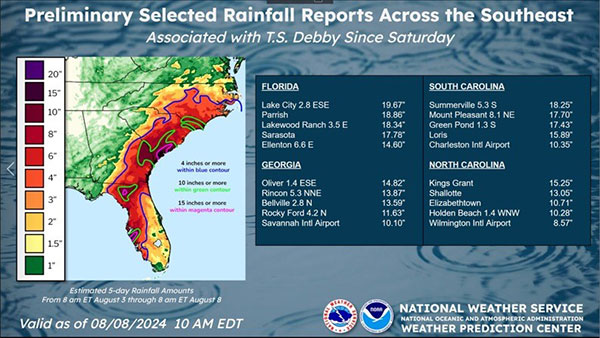
Ultimately, the model guidance proved correct. Hurricane Debby made landfall in the Big Bend region of Florida on August 5th, unleashing destructive amounts of rainfall across the Southeastern U.S. for several days. In Lake City, Florida, a flash flood emergency was issued during the estimated 19.67 inches of rainfall that ultimately accumulated by the time Debby had passed (figure 2). When Debby reached Georgia and the Carolinas as a tropical storm, a weakening trough over the Southeastern U.S. eased those steering currents that had kept Debby headed northeast, halting Debby’s forward speed to a sluggish 3 kt ( ≈ 3.5 mph) as it hovered just off the coast of Hilton Head Island, South Carolina. This stagnant behavior over open water allowed Tropical Storm Debby to slightly restrengthen before making landfall once again— this time, in the Bulls Bay area of South Carolina on August 8th, (7). Between Georgia and the Carolina’s, South Carolina received the highest rainfall accumulation with 18.25 inches estimated in the town of Summerville. North Carolina received an estimated 15.25 inches of rain in Kings Grant, a small suburb of Wilmington, while Georgia had an estimated 14.82 inches of rain in the city of Oliver, situated within Screven County (figure 2).
The National Hurricane Center’s New Experimental Forecast Cone
Just one month into the season, Beryl certainly grabbed the attention of anyone who had yet to take notice of what is forecast to be an extremely active hurricane season in the Atlantic. The bulk of activity in this basin normally occurs between mid-August and mid-October (8), but Beryl’s behavior shows that 2024 is unlikely to be a normal season. In fact, the day after Beryl made landfall, Colorado State University increased their already-well-above-average forecast for the number of tropical cyclones and hurricanes in the Atlantic basin this year (9). To improve the communication of risk to all impacted areas during tropical cyclone events, the NHC is trying out a new, experimental forecast cone graphic beginning in August. This forecast cone now includes hurricane warnings and watches for inland communities within and beyond the cone of uncertainty. Those who would otherwise feel safe from hazards because they are far from the coast or outside the cone can more easily evaluate whether or not they should expect tropical storm or even hurricane force winds (10).
Craig Setzer, hurricane and severe weather meteorologist and ACM Consulting Member, previously wrote an informative article about the cone of uncertainty— or “Cone of Confusion” as he calls it— and why some may find it difficult to properly evaluate their risk for tropical cyclone-associated hazards:
“[...] if you planned for tropical storm (or hurricane) conditions based on being in or out of the forecast cone, you would potentially be making life-threatening mistakes because the forecast cone only addresses a series of forecast points, not any of the storm’s impacts,” (11). The new experimental forecast cone begins to address this concern with a more comprehensive assessment of potential strong wind impacts. The current forecast cone we’ve grown accustomed to will remain in operation, but users of the experimental cone are encouraged to provide feedback to help the NHC understand its effectiveness, and further improve their ability to inform the public of their risk for severe hazards associated with tropical cyclones.
Heading into the Peak of the Season
The NHC will likely have several opportunities to test the new forecast cone this year. Tropical cyclone activity in the Atlantic basin tends to ramp up dramatically in August, and we’re quickly approaching the climatological peak of the season, which occurs in early to mid-September. With Hurricane Ernesto— which brought strong winds and heavy rain to Puerto Rico and Bermuda this past week— finally transitioning to a post-tropical cyclone off the eastern coast of Canada, the tropical Atlantic is currently quiet. Despite this lull, keep your storm supplies well stocked, because the Climate Prediction Center is predicting that development in this basin will become more likely toward the end of the month (15), and at this time of year, quiet in the tropics doesn’t usually last long!