Atlantic Hurricanes: A Review of 2023 and Look Ahead to 2024
Published: April 16, 2024
When we think of water, our minds often imagine what we drink, what we avoid beneath our umbrella, or the frothy surge of a mighty river. Given this ubiquitous idea of water, it may come as a surprise to learn that our planet retains an astounding 97% of its water in the ocean, leaving a relatively small percentage for everywhere else, including the atmosphere (1). In the United States, we divide the enormous ocean into five major basins: the Atlantic, Arctic, Pacific, Indian, and Southern basins (2). Each region has distinct behaviors that collectively influence global weather and climate patterns. One feature found in several ocean basins is the formidable tropical cyclone. These dramatic storms are among the strongest on Earth; they play a significant part in the exchange of energy between the atmosphere, ocean, and land. Considering their record of destruction to human and ecological communities in the U.S., the National Hurricane Center becomes rather busy during hurricane season while they diligently monitor the Eastern Pacific and Atlantic basins for activity.
A Review of the 2023 Atlantic Hurricane Season
We can further divide these regions into seven tropical cyclone “basins,” or where tropical cyclones most commonly form across the globe (3). Among these seven is the Atlantic basin, which includes the Atlantic Ocean, Gulf of Mexico, and Caribbean Sea. The Atlantic basin sees, on average, 14 named storms, seven hurricanes, and three major hurricanes per season, which runs from June 1st through November 30th (4). The 2023 Atlantic hurricane season experienced 20 named storms, seven hurricanes, and three major hurricanes, claiming #4 on the record for most named storms since 1950 (5). With a punctual beginning, Tropical Storm Arlene became the first named storm on the second day of the season (6). Tropical Storm Bret followed close behind, also earlier than average, forming in the tropical Atlantic on June 19th. Arlene had no direct impacts to land, but Bret made landfall as a tropical storm on St. Vincent and the Grenadines in the Caribbean Sea before officially dissipating on June 24th (7).
The first hurricane of the season was Don, which began as a non-tropical low between Bermuda and the Azores on July 11th. After more than a week as a tropical storm, Hurricane Don reached peak strength on July 22nd with 75 mph sustained winds and a minimum central pressure of 986 mb— a low-end category 1. Don maintained hurricane strength for a little less than a day without making landfall or causing any known damage (8).
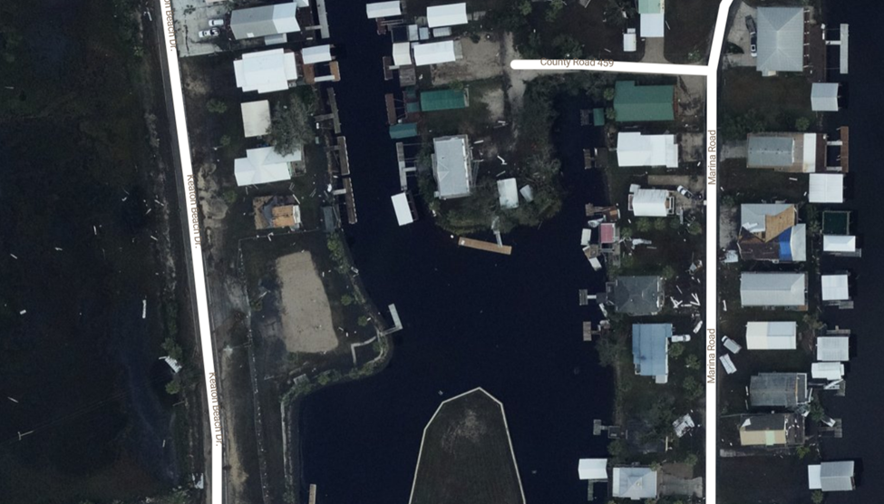
The next system to reach hurricane strength in the Atlantic was Idalia. Idalia actually began as a tropical low in the far eastern Pacific Ocean and advanced northeastward across Central America. Idalia first made landfall as a tropical depression in Cozumel, Mexico, when the system made an odd detour back southward before turning eastward, while gathering strength. On August 29th, Idalia took advantage of the overheated Gulf of Mexico and rapidly intensified. Hurricane Idalia neared the Big Bend region of Florida as a menacing Category 4; at it’s peak intensity, Idalia maintained 132 mph sustained winds and a minimum central pressure of 942 mb. However, Idalia quickly began an Eyewall Replacement Cycle (ERC) following its peak. This process can reduce the strength of a tropical cyclone temporarily, while the preexisting eyewall weakens and succumbs to a new, often stronger eyewall (9). Although Idalia might have dealt worse damage with adequate time to develop a fresh eyewall, it still made landfall as a major hurricane in Keaton Beach, Florida as a Category 3.
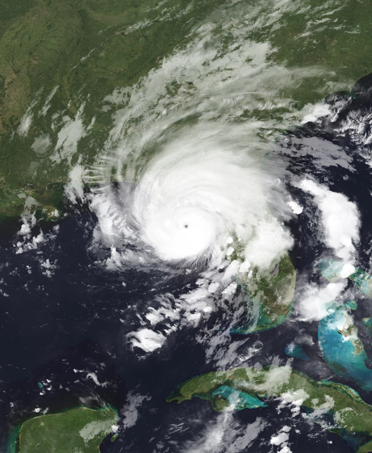
Idalia slammed into the Florida Gulf Coast on August 30th, bringing storm surge as high as 12 ft into rural wetlands along Keaton Beach and Steinhatchee. In addition to storm surge, Idalia caused substantial rain across the Southeastern U.S. The highest recorded rainfall occurred in Holly Hill, South Carolina with 13.55 inches. Twelve people died across Florida, Georgia, North Carolina, Delaware, and New Jersey. Eight fatalities occurred from dangerous surf conditions, and four more from clean-up or vehicle collisions after the storm had passed (10).
Hurricane Idalia was the most intense tropical cyclone to make landfall in the United States during the 2023 hurricane season, but it was not the most intense cyclone of the season. That honor goes to Hurricane Lee, which reached Category 5 strength while in the open Atlantic Ocean east of Puerto Rico, before it turned northward and made landfall as a post-tropical cyclone along the Canadian coast on September 16th, with sustained winds of 70 mph (11).
The 2023 Atlantic hurricane season wound down on October 29th, with the dissipation of Hurricane Tammy east of Bermuda. No named storms formed in November, during the last official month of the season.
The Impact of El Nino on the 2023 Atlantic Hurricane Season
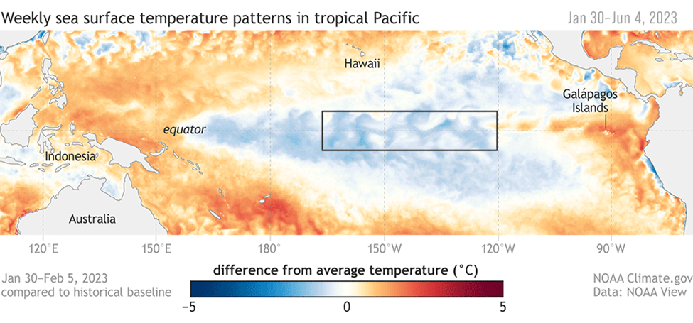
The 2023 Atlantic Hurricane season occurred during an El Nino, which is the warm phase of the El Nino Southern Oscillation, or ENSO. ENSO relates to the warming and cooling of ocean waters in the Central and Eastern Tropical Pacific. This fluctuates every three to seven years by 1°C to 3°C on average, causing shifts in global atmospheric circulation. There are three phases of ENSO: El Nino means that tropical Pacific sea-surface temperatures (SSTs) are above-average, La Nina means SSTs are below-average, and the neutral phase means SSTs are near-average (12).
The oscillation of SSTs that defines the phases of ENSO occurs in the Pacific basin, so what does this mean for hurricane activity in the tropical Atlantic? Since the ocean and atmosphere interact strongly, these changes in Pacific Ocean SSTs influence the strength and position of atmospheric features like jet streams and areas of high and low pressure across the globe. Most relevant to Atlantic tropical cyclones is ENSO’s impact on wind shear across the basin: El Nino tends to enhance wind shear across the tropical Atlantic while La Nina tends to weaken it (13). Since strong wind shear disrupts the development of tropical cyclones, we often see Atlantic hurricane activity decline during El Nino and increase during La Nina.
However, last year’s El Nino conditions did not make for a quiet Atlantic hurricane season. Instead, the Atlantic basin broke a new record for the most named storms in an El Nino-influenced season. The reason for the above-average activity in 2023 is that wind shear is not the only influence on tropical cyclone formation and strength. Warm water also plays a key role, and last year, persistent marine heatwaves across the globe triggered anomalously high SSTs, including in the Gulf of Mexico and Caribbean Sea. These record-warm waters provided fuel to developing tropical cyclones and countered the typical hurricane-suppressing effects of El Nino (5).
Closing Thoughts
As of March 14th, 2024, the NWS Climate Prediction Center (CPC) issued an El Nino Advisory and La Nina Watch (15). This means we currently remain in the El Nino phase but will likely transition into the neutral phase within the next two or three months, with a 62% chance of entering the La Nina phase within the next six months. Atlantic SSTs recorded in February of this year already resemble the average temperatures we expect to see at the beginning of hurricane season. Concerningly, the highest SSTs were recorded in the main hurricane development region (16).
If these record-breaking temperatures continue throughout hurricane season and the CPC’s La Nina watch materializes, we may see a very active Atlantic hurricane season this year. La Nina’s weaking effect on Atlantic wind shear coupled with prolonged marine heatwaves suggests a heightened potential for hurricane development and intensification. With last season’s activity breaking records despite the hurricane-suppressing influences of El Nino, this season’s early outlook indicates an even more conducive environment for hurricanes to thrive.
Highlighting this potential, Colorado State University (CSU) released its first seasonal Atlantic hurricane forecast for 2024 on April 4th, and it was the highest prediction for hurricanes that the team has ever issued with their early-season outlook (17). CSU’s forecasters expressed above-average confidence in their forecast, citing the continuation of record-warm seas and the predicted shift from El Nino to La Nina conditions. In other words, the two main predictive factors for hurricane activity – wind shear and sea surface temperatures – are both pointing toward a very active season. While we cannot predict the conditions for the upcoming hurricane season with absolute certainty, the current indicators are for well-above-average tropical cyclone activity in the Atlantic.
Stay tuned, stay vigilant, and for those of us in areas vulnerable to hurricane impacts, it’s important to begin preparations before June 1st!
References
- “Where is all of Earth’s water?” NOAA NOS
- “Oceans and coasts”
- “Seven Tropical Cyclone Basins” NOAA AOML
- “Tropical Cyclone Climatology” NOAA NHC
- “The 2023 Atlantic hurricane season ranks 4th […]” NOAA News & Features.
- “ARLENE” NHC TC Report
- “BRET” NHC TC Report
- “DON” NHC TC Report
- “Eyewall Replacement Cycle” NOA AOML
- “IDALIA” NHC TC Report
- “LEE” NHC TC Report
- “What is ENSO?” NOAA NWS
- “Weather Impacts of ENSO” NOAA JetStream
- “Ocean Heat” EPA
- “ENSO Diagnostic Discussion” NOAA CPC
- “The Atlantic is record-warm right now […]” Tampa Bay Times
- “Forecast for 2024 Hurricane Activity.” Colorado State University
- Figure 1, NASA Earth Observatory
- Figure 2, NOAA Hurricane IDALIA Imagery
- Figure 3, NWS News