Reflecting on the 2025 Atlantic Hurricane Season
Published: December 9th, 2025
With the end of the 2025 Atlantic hurricane season, we reflect on the seemingly odd dichotomy of this year’s storms: a near-average number of total tropical cyclones with a higher proportion of those storms reaching major hurricane status. Out of the five storms that became hurricanes, four strengthened to become major hurricanes.
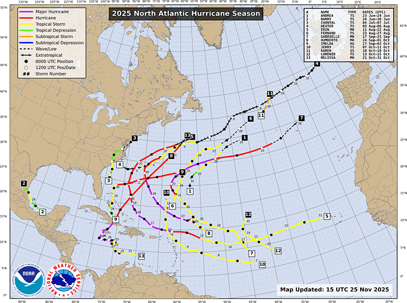
According to the National Hurricane Center’s (NHC) 2025 summary, the Atlantic basin produced 13 named storms, five hurricanes and four major hurricanes, and the season’s accumulated cyclone energy (ACE) finished modestly above average at about 132.5 (×104 kt2). This verifies this season’s forecasts from the National Oceanic and Atmospheric Administration and from researchers at Colorado State University’s Tropical Meteorology Project, who both predicted that we would see heightened activity this Atlantic hurricane season (1, 2).
Early Season
This season’s early months were nothing out of the ordinary: Tropical Storm Andrea and Barry formed in late June and were followed by a steady parade of tropical storms through July and August, including Chantal and Dexter, but several early systems were short-lived or steered away from land. However, beneath the surface, the tropical Atlantic exhibited persistent warm anomalies and a deep layer of ocean heat content that primed the basin for stronger development later in the year (3). A whirlwind of activity from late September to the end of October demonstrated how this underlying warmth can robustly fuel tropical systems once they encounter favorable atmospheric conditions.
Major Hurricanes
The late summer and early fall produced the season’s most powerful storms. The first hurricane of the season was Hurricane Erin, which became an early-season Category 5 storm during its run from August 11th–22nd. Erin had maximum sustained winds near 160-mph and a minimum central pressure around 915-mb; this system stands as the second strongest hurricane of the season by minimum central pressure and ACE (4). Hurricane Erin provided a sneak peek at the potential power lurking in the warm waters of the Atlantic basin. Fortunately, Erin spared the communities along its path from the direct impacts of a major hurricane as the storm came and went without making landfall. However, coastal communities along the eastern U.S. experienced several days of hazardous surf, powerful rip currents, high wind, and coastal flooding that eroded beaches and made some roadways impassable—especially those that link the barrier islands of North Carolina’s Outer Banks (5).
Increased tropical cyclone activity in late September and into October further tapped into the fuel provided by warm sea surface temperatures, as major hurricanes like Gabrielle and Humberto underwent rapid intensification episodes that made forecasting and preparedness more difficult. These two long-lived storms contributed significantly to the season’s elevated total ACE. Although Gabrielle and Humberto did not make landfall as tropical systems, these energetic storms sent swells and hazardous surf far from their centers, and their remnants had destructive impacts as far a way as Western Europe (6).
Hurricane Melissa and Impacts in the Caribbean
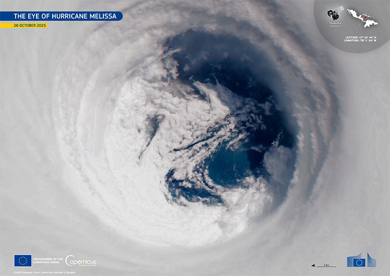
Hurricane Melissa emerged late in the season but quickly asserted itself as the storm that would define 2025 for much of the Caribbean, including countries like Jamaica, Haiti, Cuba, and parts of the Bahamas. According to the NHC, Melissa spun into the 13th tropical storm of the season over the central Caribbean Sea on October 21st. A period of rapid intensification began in the evening of Saturday, October 25th, during which time Melissa erupted from a 75-mph Category 1 to a 140-mph Category 4 in 24 hours. Melissa continued to intensify until it reached its peak intensity on the morning of Tuesday, October 28th. Melissa maintained peak intensity until it made landfall on the southwestern coast of Jamaica as a 185-mph Category 5 hurricane later that night—making Melissa one of the most intense hurricanes in recent memory (7). What makes Melissa even more extraordinary is that a dropsonde released inside the storm recorded a wind gust of 252-mph. This marks a new record for the strongest verified wind speed inside of a hurricane, according to the National Center for Atmospheric Research (8).
The Saffir-Simpson Hurricane Wind Scale (the NHC’s official hurricane rating system) is based on the average maximum sustained wind speed within the storm’s core for one minute, not wind gusts. This gust measurement does not change Melissa’s official category, but it does offer a mind-boggling glimpse of just how violent the winds near the storm’s core can be and suggests why some of the worst damage may have come from one of these extreme bursts rather than the sustained wind alone.
On land, Melissa’s effects were concentrated where its core and heavy rainbands passed close to populated, vulnerable terrain. High winds and storm surge destroyed houses, as well as power, communication, and transportation infrastructure, while extreme rainfall in mountainous islands increased the risk of flash floods and landslides. In many affected areas, agricultural losses were heavy: staple crops and smallholder farms that sustain local economies took hits that will likely extend the country’s overall recovery timeline (9). Melissa’s aftermath made clear that the true human toll of hurricane season is not measured by the number of storms, but by the depth of destruction a single storm can leave behind, especially in island communities where recovery is a long, uneven road.
Final Thoughts
Several key themes emerge when looking back on the 2025 Atlantic Hurricane season. Rapid intensification became a defining pattern: storms gaining strength faster than communities could react, shortening evacuation windows and forcing emergency planners to operate under tighter schedules.
This season also reminds us that raw statistics like named storm counts and ACE do not fully capture what people experience on the ground. Often, the “luck” of where a powerful storm makes landfall determines whether a season is remembered as a meteorological curiosity or a humanitarian crisis. Above all, 2025 reinforced the urgency of investments in resilience infrastructure like stronger building standards, and proactive disaster preparedness in vulnerable regions, including island nations and other low-lying coastal communities that bear disproportionate risk.
The NHC’s Tropical Cyclone Reports for this year’s Atlantic hurricane season provide a clear record that a season with near-normal counts can nevertheless produce multiple high-end hurricanes and a higher-than-average ACE, with consequential impacts. As recovery unfolds, the lessons learned this season will be essential in guiding future planning, improving resilience, and prioritizing more equitable support so that high-risk, lower-income countries will see fewer losses in the seasons to come.
- “NOAA Predicts Above-Normal 2025…” NOAA News
- “2025 Seasonal Forecast” Department of Atmospheric Science, Colorado State University
- “What’s Suppressing Storms During the Peak…” Association of Certified Meteorologists
- “Tropical Cyclone Reports Archive” NOAA National Hurricane Center
- “Preparedness in the Wake…” Association of Certified Meteorologists
- “Catastrophe Alert: October 3, 2025” Aon
- “Hurricane Melissa (2025) Advisory Archive” NOAA National Hurricane Center
- “Record-Breaking Winds Confirmed…” NSF National Center for Atmospheric Research
- “Hurricane Melissa 2025: NASA…” NASA Disasters Program
- Figure 1. “Tropical Cyclone Reports Archive” NOAA National Hurricane Center
- Figure 2. “Sentinel-2 Captures Vivid View…” European Union, Copernicus Sentinel-2 imagery
- “Saffir-Simpson Hurricane Wind Scale” NOAA National Hurricane Center