Preparedness in the Wake of Hurricane Erin
Published: August 26th, 2025
When Hurricane Erin roared to life in mid-August 2025, it wasted no time etching its name into Atlantic hurricane history. Emerging as a Cape Verde wave off Africa on August 9th, the system steadily organized before it earned the name Erin as a tropical storm two days later. By August 15th, Erin had become the first Atlantic hurricane of the season, and within 24-hours it underwent explosive rapid intensification, strengthening into a Category 5 powerhouse with 160-mph sustained winds and a minimum central pressure of 915-mb as it passed just northeast of the Leeward Islands. Though its core remained offshore, Erin grew into a sprawling storm whose massive wind field and powerful swells drove dangerous surf, rip currents, and coastal flooding across the Caribbean Islands and much of the U.S. East Coast. Hurricane Erin’s rapid intensification ranks among the fastest on record in the Atlantic (1). This storm’s record-setting rise and far-reaching impacts have already made Erin a defining storm of 2025—and an unmistakably dramatic start to a season that still has a long way to go.
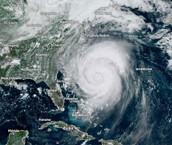
on 20 August 2025, 6:00pm UTC,Zoom Earth
Hurricane Erin’s History, Hazards, and Impacts
Hurricane Erin, the fifth named storm of the season, became both the first hurricane and first major hurricane. In fact, for the second consecutive year, the first hurricane of the Atlantic season reached Category 5 strength (see Hurricane Beryl 2024), hinting at a potential rise in how often tropical cyclones undergo rapid intensification (2). The system that became Erin initially faced challenges while it traversed through an environment with unfavorable conditions: dry air, modest shear, and sea surface temperatures less than 80°F kept the system below hurricane strength for nearly a week (3). However, as mid-August arrived and Tropical Storm Erin neared the Caribbean, conditions became ideal for intensification, and aircraft reconnaissance confirmed Erin had achieved hurricane strength. Forecasters at the National Hurricane Center (NHC) accurately predicted that Hurricane Erin would remain at sea without making landfall. But even without a direct landfall, Erin’s reach was immense and its impacts widespread. As the storm continued northeast across the North Atlantic, its wind field continued to expand dramatically—by August 22nd, Erin maintained hurricane strength as a Category 2, while hurricane-force winds extended outward in a 140- mile radius, and tropical storm-force winds reached an impressive 435 miles. Even as Hurricane Erin’s intensity weakened, the NHC maintained that “swimming at many U.S. East Coast beaches is likely to remain dangerous for a couple more days,” (4).
On the human front, Erin’s precursor disturbance caused devastating flooding in Cape Verde, when it dropped 7.6 inches of rain in only five hours on August 10th. On the islands of São Vicente and Santo Antão, over 1,500 residents were displaced from their homes, nine lives were lost, and several are still unaccounted for (5). In Puerto Rico and the Virgin Islands, Hurricane Erin’s outer rain bands brought heavy rainfall, gusty winds, power outages, and landslide warnings as the core forged ahead about 145 miles offshore of San Juan (6). Meanwhile, along the U.S. East Coast from North Carolina’s Outer Banks to the mid-Atlantic states, high-surf advisories with the potential for 15 to 20ft waves and coastal flooding concerns intensified. Rip current and beach erosion became daily hazards, and state emergency declarations and pre-emptive evacuations were issued in preparation for the dangers that an offshore storm’s indirect effects can pose (7). Erin continued to unleash life-threatening coastal impacts along the U.S. Mid-Atlantic and New England coasts into the weekend (8). The hurricane’s dangerous swells and powerful currents proved deadly in several states, with rip currents claiming lives in New York and New Hampshire, while capsized boats off the coasts of Massachusetts and Maine prompted rescue operations and ongoing search efforts (9). Erin’s offshore path may have spared direct hits, but its hazardous surf and flooding kept emergency crews and residents on high alert for several days.
The Season to Come
NOAA National Environmental Satellite, Data, and Information Service
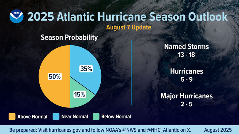
In the latest outlook, the National Oceanic and Atmospheric Administration (NOAA) continues to signal above-normal activity this hurricane season. The forecast currently stands at 13-18 named storms, 5-9 hurricanes, and 2-5 major hurricanes (10). Climatologists point to a combination of factors that may fuel this season’s volatility: warmer-than-average sea surface temperatures, low wind shear, and an active West African monsoon season all favor the rise of more tropical disturbances with the potential to become landfalling hurricanes. NOAA’s Climate Prediction Center forecasts that ENSO-neutral conditions (El Niño Southern Oscillation) will persist through early fall, followed by a short La Niña phase lasting into late winter before returning to neutral conditions (11). While ENSO-neutral conditions neither suppress nor enhance Atlantic hurricane activity on its own, La Niña’s tendency to lower wind shear in the Atlantic can allow for more disturbances to strengthen and persist as long-track hurricanes.
In short, the combination of favorable oceanic and atmospheric conditions means this season is far from over, and the Atlantic basin remains primed for more powerful storms. We’re only midway through the 2025 hurricane season, with the peak yet to come in mid-September, so both coastal and inland communities on or near the Atlantic and Gulf coasts will need to stay alert as the season progresses.
Final Thoughts
Hurricane Erin reminds us that the threat of tropical cyclones can extend far beyond landfall. Its massive wind field and the dangerous coastal conditions it produced show how even offshore “fish storms” can put lives and property at risk, meaning we should not ignore a storm simply because we are outside of its forecast cone. Following watches and warnings, monitoring forecasts, and preparing in advance with the guidance of state and federal agencies remain the most effective ways to stay safe during hurricane season.
Erin also brings to light a broader reality: storms can evolve faster than expected, leaving little lead time for vulnerable communities. Residents along the Atlantic and Gulf coasts—whether near shore or inland—must treat every tropical depression, tropical storm, and hurricane as a potential hazard, respect evacuation guidance, and stay ready for flooding, extreme wind, high surf, power outages, and other direct or indirect impacts. Erin’s legacy is more than that of a record-setting hurricane, it is a reminder that staying informed, prepared, and attentive to forecasts can mean the difference between safety and disaster.
References
- “Category 5 Erin is the first Atlantic Hurricane of 2025” NOAA NESDIS
- “A potential explanation for the global increase…” Nature Communications, Kieran Bhatia et al.
- "Tropical Storm ERIN" NOAA NHC Archive
- "Hurricane ERIN" NOAA NHC Archive
- "Cape Verde declares state of emergency..." BBC News
- "Category 4 Hurricane Erin..." AP News
- "Hurricane Erin pounds US east coast..." The Guardian
- "HURRICANE ERIN" NOAA NHC Graphics
- "Hurricane Erin leaves rough seas..." AP News
- "Prediction remains on track for above normal..." NOAA News
- "ENSO Diagnostic Discussion" NOAA CPC
- "Rapid Intensification" NOAA NHC Glossary
- "Testing the New Forecast Cone..." ACM News and Articles
- "El Nino/Southern Oscillation..." NOAA NCEI
- Figure 1, Zoom Earth
- Figure 2, "Category 5 Erin..." NOAA