What’s Suppressing Storms During the Peak of the 2025 Atlantic Hurricane Season?
Published: September 22nd, 2025
As summer winds down, the days grow shorter, the air cools, and the end of Atlantic hurricane season begins to come into view. The season officially runs from June 1st to November 30th, but its most active stretch typically falls between mid-August and mid-October, with September 10th marking the climatological peak (1). This is when the Atlantic usually produces the greatest number of storms, the strongest hurricanes, and the highest risk for coastal impacts. Yet this year, the peak has come and gone with surprisingly little action. Over the past three weeks, the basin has been unusually tame. Aside from a handful of early-season tropical storms, the record-breaking Hurricane Erin in August, and the recent development of Tropical Storm Gabrielle on September 17th, the season so far has been much less active than forecasts suggested, leaving both forecasters and the public asking the same question: why has it been so quiet?
The Forecast vs. Reality
The official National Hurricane Center forecast for this season stands at 13-18 named storms, 5-9 hurricanes, and 2-5 major hurricanes in the Atlantic (2). At one week past the peak of the season, we have only seen 7 named storms, 1 hurricane, and 1 major hurricane. At the start of September, most hurricane season metrics were running below the 1991-2020 average; by September 8th, the Atlantic had only recorded one hurricane, compared to the typical three by that point in the season (3). The number of hurricane days and named storm days also lagged behind the climatological norm (3). This came as a surprise because ocean conditions looked primed for an active year: sea surface temperatures across the tropical Atlantic are among the warmest on record, providing ample fuel for storms (3). Normally, such warmth might suggest a busy season. Instead, the Atlantic has remained relatively subdued, reminding us that warm water alone is not enough to trigger heightened activity. Tropical cyclones also need favorable atmospheric ingredients, and this year, those ingredients have been in short supply.
One of the most persistent conditions that have hindered storm development has been an unusually dry and stable tropical atmosphere. For these storms to develop and maintain strength, they need a moist, unstable environment that encourages rising motion and deep convection. But over recent weeks, the mid-troposphere—roughly 15,000 feet above the surface—has contained far less moisture than normal. Researchers at Colorado State University’s Tropical Meteorology Project, whose seasonal hurricane outlooks are among the longest-running and most widely cited in the field, note that vertical instability, a key measure of how easily air can rise, has been consistently below average (3). The result is that thunderstorms, a building block of cyclogenesis, struggle to sustain themselves. When tropical disturbances move into this environment, they weaken and dissipate before they can organize. In effect, the atmosphere has been smothering potential storms before they have the chance to earn a name.
More Atmospheric Roadblocks
Even when storms manage to overcome dry air, they face another hurdle: disruptive winds aloft. A pronounced Tropical Upper Tropospheric Trough (TUTT) has lingered over the western Atlantic, increasing vertical wind shear across large portions of the basin (3). Vertical wind shear occurs when wind blows at different speeds or directions between the surface and upper atmosphere. Too much shear tilts and tears apart developing tropical cyclones, preventing them from organizing into their defining symmetrical structure. The TUTT has also drawn in dry, stable air from the subtropics, further hindering cyclone development. Together, these upper-level dynamics have stacked the atmosphere against tropical activity during what should have been the busiest weeks of the season.
More than half of Atlantic tropical storms and nearly 85% of all major hurricanes originate from AEWs (4), or African easterly waves. These low-pressure disturbances emerge from West Africa and travel across the tropical Atlantic, acting as the “seeds” for storm formation. But this summer, rainfall over West Africa has been suppressed by sinking air, which has made these waves less robust than normal (3). Without strong AEWs, the Atlantic has had fewer chances to spin up new tropical systems. Combined with the dry atmosphere and high wind shear, the basin has been hostile territory for the kind of long-lived hurricanes typically seen in September. Furthermore, conditions in the Pacific Ocean have added another piece to the puzzle. The El Niño–Southern Oscillation (ENSO) strongly influences hurricane activity. El Niño usually suppresses tropical cyclone formation in the Atlantic by increasing shear, while La Niña tends to reduce shear and favor more storms. According to NOAA’s September update, ENSO is currently neutral, with sea surface temperatures in the equatorial Pacific hovering near or slightly below average. A La Niña watch has been issued, with about a 71% chance that this cooling phase will develop during the October-December period (5). If La Niña had already been established, the Atlantic might be seeing less shear and more favorable conditions. Instead, the basin is caught in a transitional state, with oceans warm enough to support hurricanes, but with atmospheric patterns not yet fully aligned to take advantage. However, as the western tropical Atlantic and Caribbean are very warm, and ENSO conditions in the Pacific are neutral but leaning cool, the atmosphere may set up in a way that reduces wind shear and strengthens circulation near Central America. This pattern may create favorable conditions for tropical activity to advance in the Caribbean later in the season (3).
Final Thoughts
A quiet September peak does not guarantee a quiet season. Historical examples, including just last year during the 2024 Atlantic hurricane season, show that slow seasons can give way to bursts of activity later on. Late-season storms, such as Hurricane Sandy in 2012 or Hurricane Milton last year, have proven that October and November systems can be just as damaging as those during the climatological peak in September. The experts at Colorado State University emphasize that conditions could turn more favorable as the season progresses, especially if shear relaxes, moisture increases, and AEWs regain strength. With La Niña increasingly likely to develop by late fall, the door remains open for renewed activity in the Caribbean, the Gulf, and the western Atlantic.
For now, we’re reminded that the typical peak of hurricane season doesn’t always live up to our expectations. Quiet or not, the Atlantic can surprise us at any moment, so it’s important to not let our guard down: communities should stay prepared, keep emergency plans updated, and monitor the National Hurricane Center and local forecasts closely. A calm peak doesn’t mean a safe season, as it only takes one storm to make a big impact.
References
- “Tropical Cyclone Climatology” NOAA National Hurricane Center
- “Prediction remains on track…” NOAA News
- “Discussion of 2025 Atlantic Hurricane Season…” Department of Atmospheric Science, Colorado State University
- “Climatology of African Easterly…” NOAA Climate Program Office
- “El Nino/Southern Oscillation (ENSO)” NOAA National Centers for Environmental Information
- “Tropical Upper-Tropospheric Trough” NOAA Glossary
- “African Easterly Waves” American Meteorological Society Glossary
- “El Nino/Southern Oscillation Definition” NOAA National Centers for Environmental Information
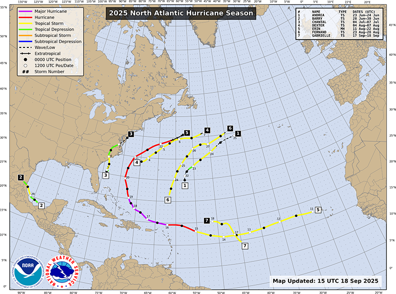
- Figure 1., “2025 Atlantic Hurricane Season” NOAA National Hurricane Center.