
The Saharan Air Layer: How the Dust Affects Weather Across the Atlantic
Published:
With the Atlantic hurricane season in full swing, the topic of the Saharan Air Layer continues to be discussed as a factor contributing to the dearth of storms we are seeing strengthen into named systems this year. The Saharan Air Layer (SAL) is a mass of extremely dry, dusty air that travels over the Sahara Desert in the late spring, summer, and early fall. Though it starts in Africa, its impacts extend well across the globe [1]. The air mass contains about 50% less moisture than the typical tropical atmosphere [2]. It is often tracked by satellite and can limit the formation of tropical cyclones in the Atlantic by bringing warmth, dryness, and strong winds to the area.
What Causes Formation?
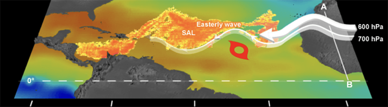
SAL activity peaks late June to early August when new outbreaks normally occur every 3-5 days. During this time, the SAL typically reaches further west and can extend all the way into central America. The SAL typically forms when tropical waves, or ripples, occur in the lower to mid atmosphere and move along the southern edge of the Sahara desert. Strong surface heating combined with westward moving air across the desert is what kicks the dust into the atmosphere [3]. As the SAL heads west, the hot dry air is undercut by cooler, moist air creating about a 2-2.5 mile thick atmospheric layer with the base at about 1 mile above the surface.
The African Easterly Jet
The strong horizontal temperature gradients along the leading and southern borders of saharan air layers cause strong geostrophic winds. The difference in these geostrophic winds at different altitudes (strong winds in the SAL layer and lesser winds outside of it) form the midlevel African Easterly Jet (AEJ). The jet creates intense horizontal and vertical wind shear around 6,500-14,500 feet [2]. The jet also contributes to ageostrophic transverse circulation (meaning airflow that is perpendicular to the normal pattern). Convection beneath the SAL can be enhanced by instability and moisture below the dry SAL while the SAL’s dry, warm air can actually suppress convection within and above the layer. The jet can also lead to tilting of the tropical cyclone vortex- or the circulatory, rotating pattern that characterizes tropical cyclones and that is driven by low pressure at the center of the storm. This can disrupt the system’s internal heat engine, slowing the pattern of evaporation and condensation, thereby limiting tropical development [4].
Warm Temperatures
The base of the SAL is often 5-10° warmer than a typical moist tropical air mass [5]. Though the air is originally warm due to its origins over the Sahara, the layer remains warm due to the minerals of the actual Saharan dust absorbing sunlight. The warming of this layer then causes a temperature inversion within the lower atmosphere just above the SAL, stabilizing the atmosphere and limiting vertical motion through the SAL. In turn, this suppresses cloud formation and limits thunderstorm activity with the presence of the SAL. Thunderstorms are the basis of tropical cyclone formation by providing deep convection, latent heat release, and vorticity needed for a tropical cyclone to form. If no thunderstorms can form, that means no tropical cyclones are forming either.
SAL Effects on Tropical Cyclones
Though effects of the SAL on tropical cyclones is an area of ongoing research, and those effects vary based on many factors from storm to storm, the SAL appears to affect tropical development in 3 main ways:
1. Introducing dry, stable air
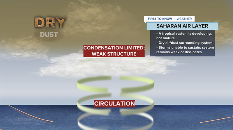
Dry air from the SAL gets pulled into outer rain bands of a tropical cyclone, causing water droplets to evaporate, dropping air temperature. Because of the drop in temperature, the cold air becomes heavy which forces rapid downward motion instead of promoting updrafts, weakening the cyclone instead of strengthening it.
2. More vertical wind shear
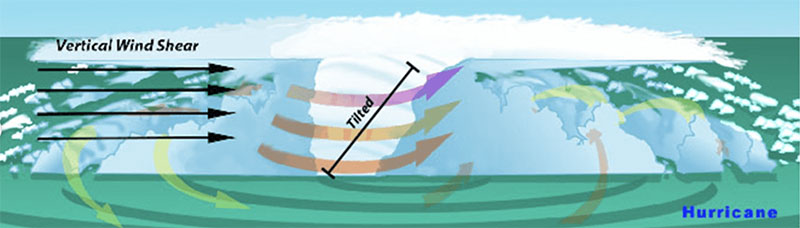
High levels of wind shear tilt the storm’s rotation axis, causing the separation of low level circulation from upper level convection. The shear brings in more dry air to the storm, preventing warm moist air from concentrating over the center and thereby limiting strong updrafts that would lead to thunderstorm formation.
 - 2A - 2B
www.aoml.noaa.gov/behind-the-2015-atlantic-hurricane-season-wind-shear-tropical-cyclones/
3. Enhanced trade wind inversion
Mineral dust within the SAL absorbs incoming solar radiation, heating the layer and creating a temperature inversion that acts as a thermal cap and traps warm, moist air near the surface. This does not allow for that moist, warm air to rise, once again limiting updrafts that leads to thunderstorm formation.
SAL So Far This Season
This year, we have been experiencing a late season plume of Saharan Dust [6]. In mid-August, we are still tracking large amounts of Saharan dust moving across the Atlantic. Our relatively quiet Atlantic hurricane season so far can be partially attributed to this (in combination with El Nino).
The SAL limits not only tropical cyclone development but thunderstorm development in general, which has also made this summer exceptionally hot in places like Florida and the Caribbean, where normal climatology calls for daily afternoon thunderstorms to interrupt daytime heating. Without that cooling influence of afternoon storms, temperatures continue to rise throughout the afternoon. However, there is a bright side to the SAL, as it brings some beautiful sunrises and sunsets. When the dust overspreads an area, it scatters sunlight creating vibrant orange hues at dusk and dawn when the sun is low to the horizon. The sight paints a picturesque reminder of the dusky blanket in the sky, while simultaneously keeping hurricanes temporarily at bay - a sight probably best enjoyed with a nice, cold glass of ice water on a hot summer evening.
References
- The Saharan Air Layer: What is it? Why Does NOAA Track It?
- The Saharan Air Layer and Extreme Weather
- Reevaluating the Role of the Saharan Air Layer in Atlantic Tropical Cyclogenesis and Evolution
- An Analysis of Tropical Cyclone Vortex and Convective Characteristics in Relation to Storm Intensity Using a Novel Airborne Doppler Radar Database
- Tropical Cyclones Saharan Air Layer
- Saharan dust cloud the size of the continental US is impacting summer weather and you may not have even noticed

