Record Rain, Failed Systems, and Lives Lost in the Texas Hill Country Floods of July 2025
Published: July 28th, 2025
On the night of July 3rd, 2025, residents and visitors in the Texas Hill Country fell asleep under cloudy skies, many unaware that a catastrophic flood event was about to unfold. By sunrise, torrential rains had unleashed flash flooding that devastated communities along the Guadalupe River, especially in Kerr County, where the river crested at 37.5 feet—nearly 20 feet higher than its major flood threshold—in just a few hours (1). Campsites, low-lying neighborhoods, and roadways were inundated with little warning from local officials. The death toll currently stands at 136 with four people still unaccounted for, marking one of the deadliest flood events in Texas history (2). Among the hardest hit were summer camps packed with children and staff who had little time to react as rapidly rising waters swept away cabins and vehicles. In Kerr County and surrounding areas, hundreds of heroic rescues took place by first responders and residents alike, but the scale and speed of the flood overwhelmed emergency response systems, leaving some people to seek refuge on rooftops or cling to trees until rescue came. This tragic event not only exemplified the potential consequences of short-duration extreme rainfall in a hydrologically vulnerable region, but it exposed some serious shortcomings in our flood warning systems, limitations with current FEMA flood maps, and the challenges of forecasting extreme weather events.
Meteorological Context
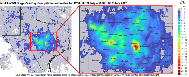
While the flood threat was on meteorologists’ forecast in the days leading up to the event, accurately predicting the timing, intensity and exact locations of flash floods remains a formidable scientific challenge. The atmospheric conditions that triggered the flooding was a convergence of Tropical Storm Barry’s remnant circulation, which became a Mesoscale Convective Vortex, and ongoing thunderstorm activity in the region, which together stalled over the Texas Hill Country from July 3rd to 7th. This set-up was further fed by an area of high-pressure situated in the Gulf that steered low-level moisture into the state, as well as significant upper-level moisture coming from the East Pacific (3). Several locations in the Hill Country—including Kerr, Mason, and Tom Green counties, to name a few—recorded more than 10 inches over the 5-day period, with most of that rain occurring between July 3rd and 4th. On the junction of Burnett, Williamson, and Travis counties, rainfall totals exceeded 20 inches during this multi-day event (4)
The unique geology of the Texas Hill Country amplified the flood’s intensity. Beneath the surface lie thin, rocky soils over impermeable limestone, which limits filtration and causes rainfall to run-off almost immediately. Combined with the region’s topography, this fast-draining landscape funnels water down steep hillsides and into creeks and rivers at alarming velocities. To make matters worse, the region was already strained by prolonged drought, with much of Kerr County classified under D4 “exceptional drought” conditions. This combination of hardened soil and reduced vegetation left the land unable to soak up the deluge, dramatically accelerating run-off and channeling more water into the Guadalupe river’s watershed than even the forecasts had anticipated (1).
The Inefficiency of Current Warning Infrastructure
Among the more preventable shortcomings exposed by this event was the failure to effectively alert residents in time. Although the National Weather Service issued timely emergency alerts, including dozens of flood watches, warnings, and nine flash flood emergencies between July 3rd to 6th (5), the rapid escalation of river levels in those early hours of July 4th outpaced emergency officials’ warning mechanisms, catching many asleep and off-guard. Hunt, a small community in western Kerr County, saw the Guadalupe River rise two feet in merely five minutes, shortly before 4:30am on July 4th. In just 45 minutes, the river rose more than 26 feet at Camp Mystic, a nearly century-old summer camp for girls that became a tragic focal point of this disaster (1). Such rapid-onset flooding creates challenges for real-time forecasts and emergency response—especially in counties like Kerr, where warning infrastructure is limited and outdoor sirens for severe weather, including tornadoes and floods, are nonexistent. In addition to outdoor sirens, local emergency management in Kerr County failed to initiate wireless alerts through FEMA’s IPAWS—Integrated Public Alert and Warning System—until well after the flood had already begun. Instead, local officials sent out an alert via CodeRed, which requires users to sign up in order to receive such alerts. This left a large swath of the population, including children and tourists, without direct warnings (6).
A Need for Improved FEMA Flood Maps
One of the most sobering lessons from the 2025 Texas Hill Country flood is how FEMA’s flood maps underestimate flash-flood risk in terrain like the Hill Country. These maps are primarily based on riverine models, outdated risk assessments, and historical flood recurrence intervals (100-year, 500-year floods), meaning they often underprepare for intense, rainfall-driven flash floods, especially along creeks and tributaries rather than major rivers (7). At Camp Mystic, for example, FEMA’s Flood Insurance Rate Maps (FIRMs), which is used to help guide floodplain management strategies, originally placed the site within a designated 100-year Special Flood Hazard Area—but 30 buildings were subsequently granted exemptions (2013-2020), removing them from regulation, insurance requirements, and stricter building oversight. Dozens of those buildings later flooded, with fatal consequences (8). Critics highlight that FEMA’s maps are outdated, rely on static boundaries, and exclude flash flood hazards, especially in areas with steep terrain and drought-hardened soils. These limitations leave many properties inaccurately classified as low-risk—and therefore uninsured and ill-prepared (7). Without updated models that reflect real-time rainfall dynamics, evolving land use, and climate-driven extremes, such maps will continue to fall short in protecting vulnerable communities.
Final Thoughts
The flood that struck the Texas Hill Country this month was sudden, violent, and unforgiving. But this was not an event that arrived entirely without warning. Meteorologists identified the threat days in advance and issued proper advisories when necessary. The science was as sound as could be, but in too many places, the systems built to act on the science were not. Inadequate flood plain policy and gaps in emergency alert infrastructure left vulnerable residents with too little time and too few options. The results were devastating. More than a hundred lives were lost, and countless more were forever changed. Families and friends mourn loved ones, while communities mourn their homes and sense of safety. The lessons from this event are painful, but they offer a chance to improve where we can: to modernize flood maps, invest in reliable warning systems, and center resilience in how we plan for the future. Doing so will require not only new policies, but also a deeper respect for the uncontrollable forces of nature, and a steadfast commitment to protecting those most vulnerable to its extremes.
References
- “Guadalupe River Flood Tragedy” NASA EarthData
- “Body of Missing Woman Found” ABC News
- “Texas Hill Country hit by powerful floods”, NASA SVS
- “Summary of the Texas Central Floods...” SW3E UC San Diego
- “Flood Emergencies Spread to near Austin...” Fox Weather
- “FEMA records show Kerr County didn't alert...” NBC Dallas-Fort Worth
- “FEMA's flood maps often miss...” CBS News
- “FEMA removed dozens of Camp Mystic buildings...” AP News
- “Major Flood Stage” NWS Glossary
- “Mesoscale Convective Vortex” AMS Glossary
- “Flash Flood Emergency” NWS Severe Weather Awareness
- “Integrated Public Alert and Warning System (IPAWS)” FEMA
- Figure 1, “Summary of the Central Texas Floods”