Nor’easters: What They Are and What You Can Expect This Season?
Published:
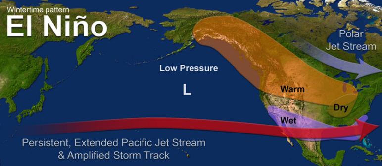
It’s no secret where Nor’easters get their name. Nor’easters are storms that typically form along the east coast of North America. Their memorable name comes from key features of these mid-Atlantic storms. The strongest winds typically blow from northeast, over the northeastern U.S. states as the system moves northeastward, pushed by the jet stream. Nor’easters usually develop somewhere along the east coast between Georgia and New Jersey within 100 miles of the Atlantic coast [1]. Typically, these systems reach their maximum strength near the New England area. The main impacts of nor’easters are heavy precipitation, whether it be rain or snow, in addition to gale force winds, rough seas, and the possibility for coastal flooding.
How Do Nor’easters Form?
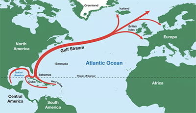
Nor’easters can occur at any time of the year; however, typical formation occurs between September and April. During these months, the polar jet stream often blows cold air southward from Canada and eastward toward the ocean. When it does so, the zone within about 100 miles of the northeast Atlantic coast becomes the perfect breeding ground for these types of systems [2], because awaiting that influx of cold, Canadian area is the Gulf Stream. The Gulf Stream is a strong ocean current that transports warm waters (and relatively warm air above those waters) from the Gulf into the northern Atlantic Ocean, extending all the way up along the east coast of the United States and Canada [3]. When the cold and warm air meet, a low-pressure system can form over the Atlantic. This low-pressure system then leads to clouds and storm development. Temperature differences like these power mid-latitude cyclones. The larger the difference between the warm ocean waters, along with warm moist air above them, and incoming cold continental Canadian air, the stronger these systems can become. The cooler months typically create a greater temperature difference between cooler continental air and warmer marine air because the land cools off quickly while the ocean remains relatively warm.
How Does El Niño Impact Our Nor’easter Forecast?
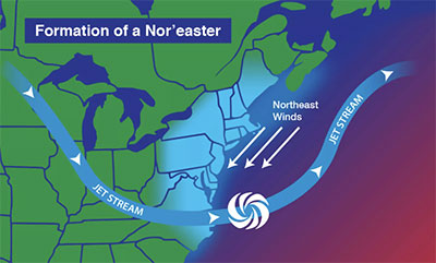
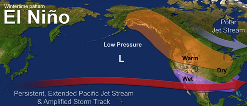
One of the large-scale systems that El Niño affects is the jet stream. El Niño conditions tend to push the polar jet stream further north while amplifying the subtropical jet stream further south, leading to a rainier winter across the southern U.S. [4]. All of this additional moisture that moves across the subtropical jet stream has the potential to be brought into a nor'easter forming just east in the Atlantic. Research has found an increased frequency of nor’easters during El Niño periods. Storms that follow a track from south of Cape Hatteras along the east coast are the main contributor to this increase. Some of the strongest nor’easters on record occurred during El Niño years. The “Perfect Storm” of 1991 brought 15 to 30 foot waves to coastal New England during one of the strongest El Niño events on record [6]. The blizzard of ‘58 and a March Nor’easter in the same year both occurred in conjunction with El Niño conditions. The March nor’easter was a violent, late-season storm bringing up to 40 inches of snow to parts of the Northeast [7].
Past Nor’easter Impacts
On October 28, 1991, a low-pressure system formed just east of Nova Scotia, Canada. It was later remembered as the “Perfect Storm” and impacted regions across the northeast. The storm brought hurricane force winds, major coastal flooding, and huge waves across the Atlantic. A 72-foot commercial fishing boat, last seen northeast of Sable Island, sank and took its six-man crew down with the ship [8]. The March nor’easter of 1958 brought heavy waves and winds, damaging boardwalks and homes. With some regions getting near 50 inches of snow, the weight of the snow collapsed roofs, porches, and sheds. People were out of power for days and clean-up efforts sometimes led to frostbite or other medical issues due to physical exertion.
Activity Begins Already
On September 26, 2026, an early season nor’easter arrived along the Atlantic coast. High pressure over eastern Canada and low pressure over the eastern seaboard created a tight pressure gradient across the eastern U.S. This has allowed for strong northeasterly winds. Several locations near both Massachusetts and New Jersey saw over 6 inches of rain [5]. Eight states were recorded to have seen wind gusts over 50 mph. Montauk point, near the Eastern edge of Long Island, recorded a 81 mph gust. Parts of New Jersey, Rhode Island, and Massachusetts saw gusts over 70 mph.
References:
- What is a Nor’easter?
- What is a Nor’easter?
- “What is the gulf stream?”
- “What we talk about when we talk about the jet stream and El Niño.”
- “Early nor'easter hammered East with coastal flooding, winds, rain”
- “El Niño Impacts and Outlook: Potential Winter Impacts”
- “Major Winter Storms”
- Remembering the “Perfect Storm”