Flooding in Hawaii: Why the Islands See Frequent and Intense Flooding
May 8th, 2026
Recent Extreme Flooding
This March, Hawaii was hit by three consecutive storm systems that brought flooding rains to the islands. These systems, known as kona lows, are subtropical cyclones that occur during the cooler season in the North Central Pacific [1]. Kona lows form on the west/northwest side of the islands, and their circulation drives a strong southwesterly wind component that replaces the normal trade wind pattern (northeasterly). These systems draw in deep tropical moisture and deposit it on the normally-drier leeward side of Hawaii’s mountains.
Often, Kona lows become pinched off from the jet stream - the band of strong, high-altitude wind that encircles the globe and provides a steering influence for storm systems. Once detached from that steering flow, Kona lows tend to meander slowly, pummeling the Hawaiian islands with days of heavy rain and high winds.
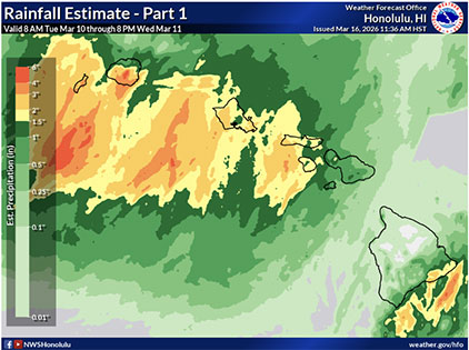
The first Kona low that contributed to intense flash flooding in Hawaii came March 10-16. Mesonet stations around Hawaii recorded near 140 mph winds and over 5 feet of rain to Maui in localized areas [2]. The most extreme rainfall was recorded at the upper elevations of Haleakalā. Air on the north and south sides of the mountains lifts and converges near the peaks, so it’s no surprise that an area of high elevation saw the highest amounts of rain. Another aspect of Haleakalā’s weather is the Maui Vortex. Trade winds approach, and because of the mountains, air is forced to go around them and split. This then causes air on the leeward side to become unstable. Here, a vortex forms and a rotating eddy- or pocket of gusty winds- occurs.
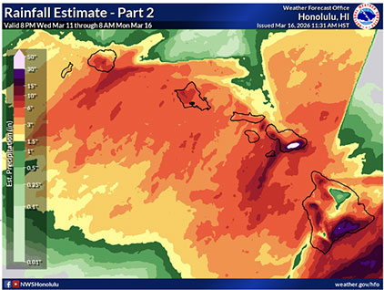
After the islands had already been seeing consistent heavy downpours from the first system, a second Kona low approached from March 19-23. This time, bringing another 5 feet of rain to localized areas. Hawaii’s North Shore faced devastation due to flooding in the communities of Waialua and Haleiwa. Homes and vehicles were inundated with water or swept away by the floods and many residents needed to be rescued [4]. According to data collected from Hawaii's Mesonet stations, a record-breaking two day rainfall total of 22 inches was recorded in Ka’ala and 19.67 of those inches were over a 24 hour period on March 19 [2].
https://www.weather.gov/hfo/marchSevere2026_continued
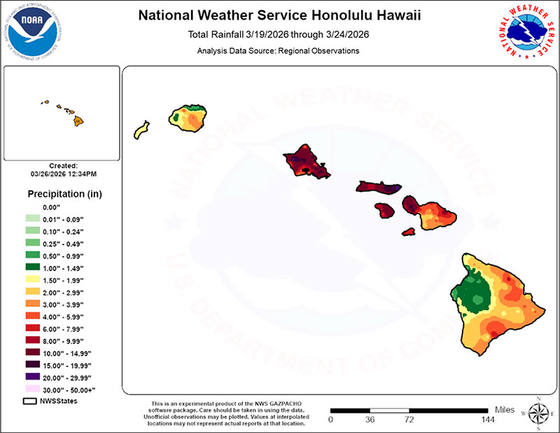
After two Kona lows stormed over the islands, the heavy rain was not yet over in Hawaii. In early April, after the previous back-to-back Kona lows in March, another Kona low pounded the region. Rain infiltrated the already saturated soil, and fueled even more flash flooding in the region [5].
Hawaii’s Familiarity with Heavy Rainfall
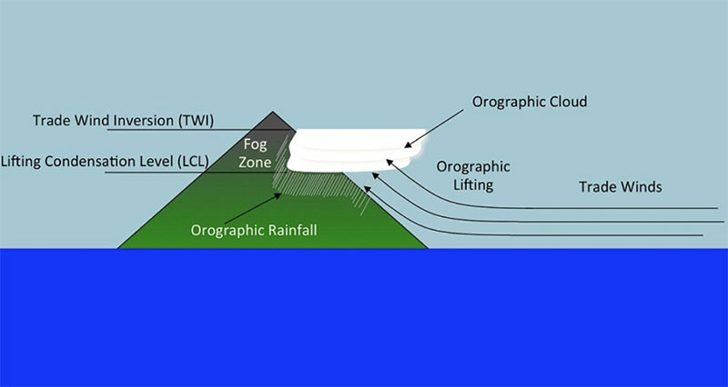
The flooding that occurred as these three systems impacted the region was the worst flooding Hawaii has seen in 20 years, but flooding is no stranger to the islands. The state’s mountainous terrain creates lots of precipitation through a process called orographic lifting. When fronts and trade winds push against Hawaii’s tall mountains, they act as a wall, meaning there is nowhere for the air to travel but up. Once the air rises, it cools to form clouds and rain. When the precipitation occurs, it falls on the mountains, accelerates down along the sides and then builds up in streams and low-lying areas which results in flash flooding [6].
Multiple components play a part in Hawaii’s precipitation pattern. Besides orographic lifting, another is a phenomenon called trade wind inversion. The trade wind inversion is a thin layer of air around 2,200 m above sea level. Here, the air gets warmer instead of cooler as elevation increases, which acts as a cap on buoyant upward motion [6]. Instead of continuing to rise, the moist air wraps around the mountains. This means the top of the clouds are located at the bottom of the trade wind inversion layer, so when rainfall occurs, the top of the mountains that extend into the trade wind inversion layer stay dry. The inversion layer acts as a lid, capping the vertical growth of storm clouds which leads to more frequent, lighter showers under normal conditions. However, when troughs and storm systems like Kona lows move through, they break the lid and allow for much taller vertical cloud growth and deeper convection. This allows for longer and more severe showers and thunderstorms. Hawaii’s mountainous terrain makes this upward lifting process even more efficient during events like Kona lows.
https://web.archive.org/web/20221210025346/http://rainfall.geography.hawaii.edu/rainfall.html
Similar to Florida’s climate, Hawaii precipitation is also affected by seabreeze convection. This seabreeze acts similarly to a cold front. The wind moves onshore during warm afternoons when the land gets warmer than the ocean, resulting in relatively low pressure over the land and high pressure over the water. As winds make their way inland, they converge, causing air to rise and more precipitation over the island. In Hawaii, these seabreezes also undergo orographic lifting as winds come in contact with mountains and have no where to go but up.
Looking Ahead to Next Year
As forecasters are anticipating a transition into El Nino conditions over the coming months, a drier winter rainy season is expected for Hawaii next year. During La Nina, the Pacific jet stream contracts, taking it more westward, resulting in more favorable conditions for cold fronts and low pressure systems like Kona lows. The Pacific jet stream is like a conveyor belt for these storms. El Nino makes for dryer conditions and generally less Kona lows due to the eastward expansion of the jet stream. The shift places Hawaii under a region where sinking air prevails, limiting the area’s typical amount of cloud formation [7].
- “Synoptic Structure and Evolution of a Kona Low”
- “2 trillion gallons of water trigger historic flooding in Hawaii”
- “Rainfall and wind summaries from March 10-16, 2026 severe weather”
- “Rainfall summary from the continuing March 19-24, 2026 flash flood”
- “Hawaii faces flash flooding as third Kona Low in a month soaks islands in torrential rainfall”
- “Hawaii’s Rainfall Patterns”
- “Surf’s Up: How Does ENSO Impact Hawaii?”