El Niño Has Arrived: What Does It Mean For Our Weather
June 30th, 2026
Defining ENSO and El Niño
Every few years, the sea surface temperatures across the central and eastern tropical Pacific Ocean warm or cool due to a recurring climate pattern called the El-Niño Southern Oscillation (ENSO). This warming and cooling pattern affects weather worldwide. El Niño and La Niña are the two extreme phases of the ENSO cycle with an ENSO-neutral phase in between, defining the period when sea temperatures are close to average [1]. As of June 11th 2026, the National Weather Service has declared the onset of El Niño conditions. During El Niño, trade winds weaken, pushing warm water back East toward America’s west coast [2].
El Niño conditions are demonstrated by above average sea surface temperatures (SSTs) in the Pacific. Warm water is pushed back East due to the weakening of trade winds. The National Weather Service (NWS) declares an El Niño has formed when temperatures in the equatorial Pacific are 0.5°C above average for several consecutive months [3]. Another factor identifying the arrival of El Niño conditions is a pattern known as the Walker Circulation.
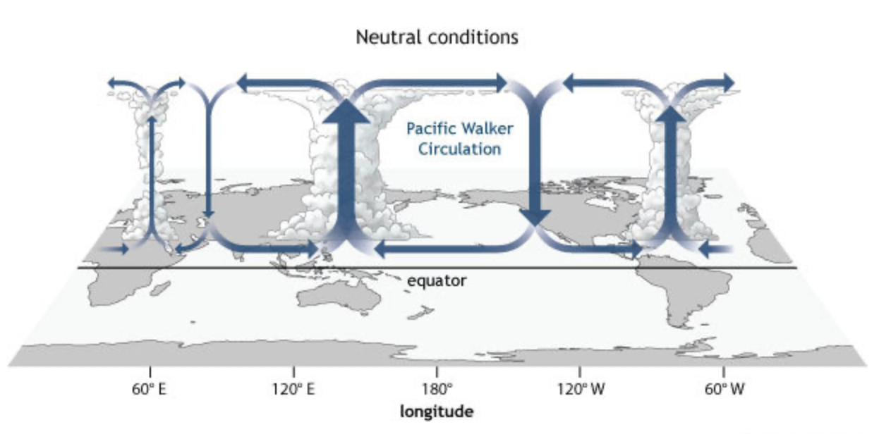
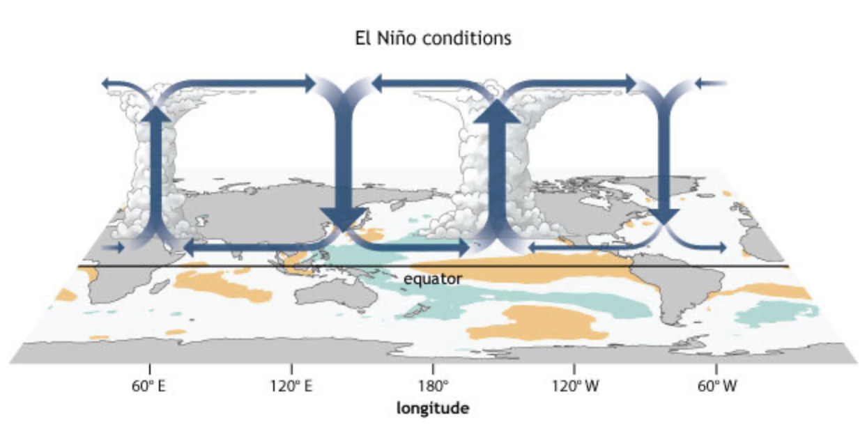
The temperature and pressure differences between the warm western and cool eastern oceans causes a massive east-to-west air flow. When this air mass begins to break down and warm water shifts eastward, El Niño is declared [3]. Although El Niño is defined by changes to sea surface temperature patterns, because the atmosphere and ocean systems are closely coupled (i.e. interact and influence each other), El Niño also produces marked changes to temperature and precipitation patterns across the globe.
What data indicate El Niño is in place?
Numerous oceanic and atmospheric markers, which are regularly monitored by scientists, confirm that El Niño has arrived [4]:
- Increase in above normal equatorial Pacific SSTs since Mid-April
- Below-average equatorial SSTs in the Western Pacific over the last month
- Equatorial SSTs near to above average in the Atlantic and Indian Oceans over the last month
- Positive equatorial SST anomaly changes across the central and eastern Pacific Ocean
- Negative changes in most of the Atlantic Ocean and in the far western Pacific Ocean
- Negative outgoing longwave radiation (OLR) anomalies (enhanced convection/rainfall) observed over the central and eastern equatorial Pacific over the last month
- Western wind anomalies expanding across most of the equatorial Pacific
- At times, regions of upper-level anomalous divergence (causing increased storm development/enhanced rising motion) shifted eastward
- Lower level anomalous divergence (the descending branch of the Walker circulation causing sinking air leading to drier weather) mostly persisted over the west-central equatorial Pacific
- Anomalous lower level convergence (rising air leading to wetter weather) evident over the eastern Pacific
The Relative Oceanic Niño Index (RONI) is also used for ENSO forecasting. The RONI calculates ocean temperature anomalies in the key equatorial Pacific zone, but subtracts the temperature anomalies of the mean global tropics. Thus, creating a relative baseline to measure how the tropical atmosphere will behave by placing current events into a historical perspective [4].
How does El Niño affect weather in North America?
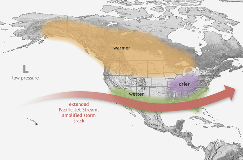
In the northern hemisphere, the impacts of El Niño are usually most intense during the winter months. Over the northern U.S., El Niño typically means a warmer winter, while the southern U.S. sees a wetter season. The jet stream over the north Pacific Ocean tends to sink southward during an El Niño winter, shifting the storm track over the southern portion of the country. This, in turn, leads to a drier than normal winter for the Northern Rockies and the Ohio and Tennessee valleys, with wetter conditions in the southern U.S., along the track of the jet stream [3].
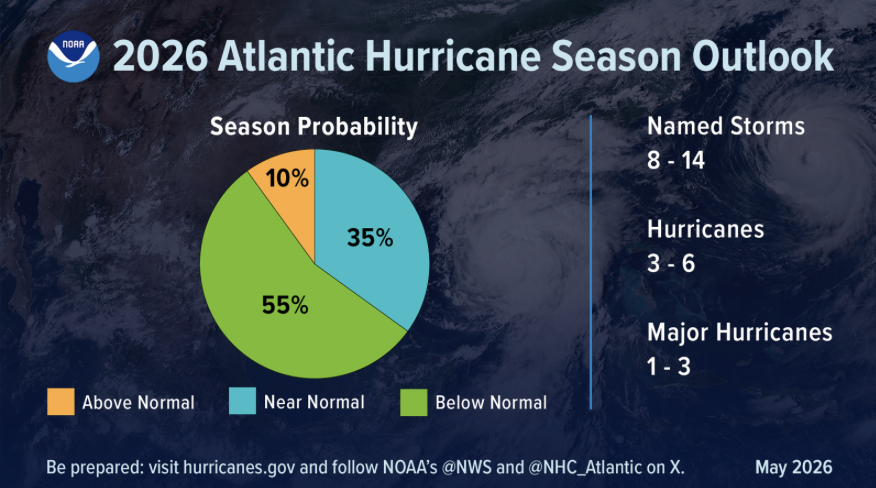
What can we expect from hurricane season with El Niño conditions?
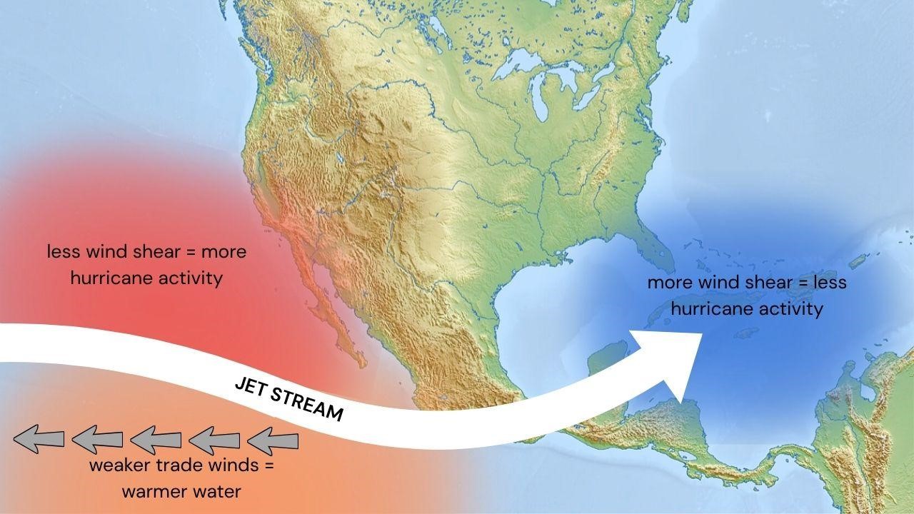
El Niño generally lessens tropical cyclone development in the Atlantic basin due to an increase in windshear that makes it harder for thunderstorms to organize into a tropical system [5]. Accordingly, forecasters are predicting a slightly below average Atlantic hurricane season for 2026. Conversely, in the Pacific, warmer waters provide more energy for storms to form and strengthen while decreased wind shear allows for storms to more easily organize themselves into tropical lows.
Implications of a Super El Niño Event
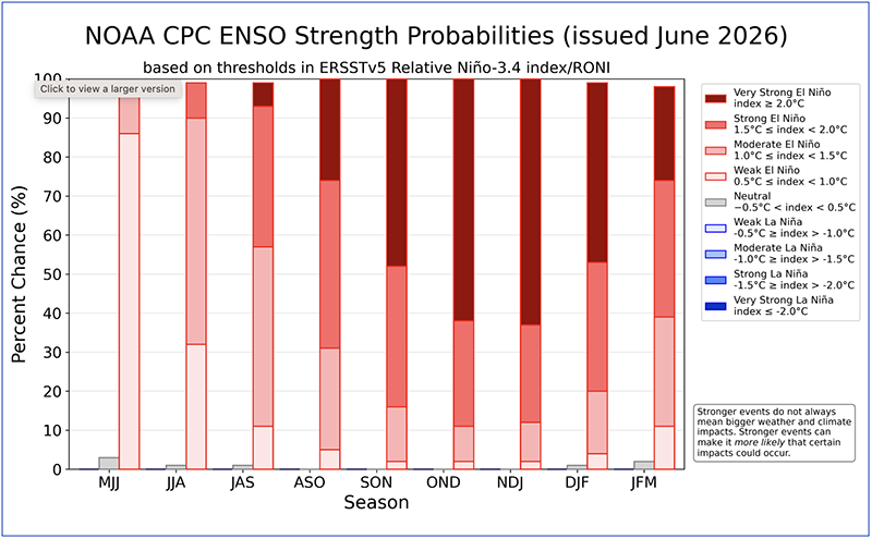
The National Weather Service says there is a 63% chance of development into a Super El Niño between November and January. If this occurs, it would rank as one of the largest El Niño events on record back to 1950 [7]. While very strong El Niño events do not necessarily mean extreme impacts everywhere, Super El Niño events increase the probability of such impacts. A super El Niño can also increase global temperature averages by up to 0.2°C. This results in intensified heat extremes across the globe.
References
- “What is ENSO?”
- “What are El Niño and La Niña?”
- “El Niño forms, expected to strengthen, say NOAA forecasters”
- “ENSO: Recent Evolution, Current Status and Predictions”
- “How does El Niño Impact Atlantic Hurricane Season?”
- “NOAA Predicts Below Normal 2026 Atlantic Hurricane Season”
- EL NIÑO/SOUTHERN OSCILLATION (ENSO) DIAGNOSTIC DISCUSSION