
Defining Downbursts and Why They Occur
What are downbursts?
Downbursts are strong thunderstorm downdrafts that cause an outflow of horizontal winds near the surface. With such strong winds, observers commonly mistake downbursts for tornadoes, but a downburst is a completely different event. Downbursts are defined by both Fujita and Wasimoto scales. They are categorized by size into two different types known as microbursts and macrobursts.
Macrobursts are defined as large downbursts having an outflow diameter of 4 km or greater with damaging winds persisting for 2 to 5 minutes, while microbursts are divided into two different types: dry and wet microbursts. The dry microburst has little or no precipitation during outflow and is usually associated with virga- precipitation that falls but evaporates or sublimates before it reaches the ground. Dry microbursts are common in the high plains and intermountain west [1]. In contrast, wet microbursts are associated with heavy precipitation during the outflow period and normally, a strong, visible column of precipitation descending from thunderstorms [2].
What causes downbursts?
When a thunderstorm starts building, a strong updraft leads the process. As the cloud grows vertically, rain and hailstones begin to form. As the storm continues maturing, the updraft brings more moist, unstable air to the cloud and raindrops and hail become large enough to fall to the ground. If the updraft is strong enough, rain and hail are suspended and accumulate in the middle and upper parts of the storm while drier air can develop in the middle and low parts of the storm due to strong flow on the backside (see Figure 1) [3].
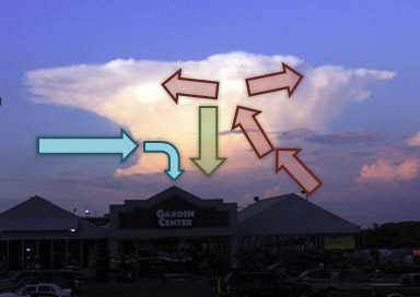
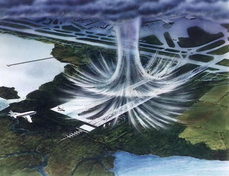
In a downburst, once the updraft has weakened so much that it is no longer strong enough to hold that load of precipitation, the load that the updraft was storing in the upper part of the storm is released. As it falls, it drags the air downward while plummeting rapidly towards earth’s surface. When the downdraft reaches the surface it spreads in all directions, similar to water from the faucet hitting the sink [4]. If the air at the surface has low relative humidity, the downdraft’s speed will increase even more as the rain entering the region of dry air evaporates and cools the air, making it heavier [3]. An additional current of dry, environmental air entering the upper part of the storm can increase cooling evaporation further, making the downdraft even stronger.
Typically winds from a downburst are considered straight-line winds. However, they also rotate, but differently than tornadic winds do. As the winds hit the ground, they curl upward, rotating around a horizontal axis while tornadoes rotate on a vertical axis (see Figure 2) [4].
Effects of Downbursts
Downburst wind speeds can exceed 100 mph, as strong as some tornadoes. Both people experiencing a downburst and viewers watching from afar commonly mistake it for a tornado or heavy rainfall. Downbursts have the capacity to blow out glass and damage building structures. In cities, the strong winds can deflect around and ricochet off buildings, increasing the pressure they apply to other, nearby buildings [5]. Even buildings built to withstand hurricanes can be damaged from these storms.
Derechos (widespread wind storms with a band of fast moving showers and thunderstorms) often consist of multiple, microbursts, downbursts, or downburst clusters [1]. An example of these severe storms was seen on July 29th in Hyde County, South Dakota. The area was hit with what the Storm Prediction Center has classified as a “mini-derecho”- because the storm extended less than 100 km wide. As the storm passed, it brought 2.5 inch hail and wind gusts up to 131 mph [5]. Eastern South Dakota was left with roofs torn off of homes, vehicles toppled over, and even wind turbines bent completely in half [6]. The storm traveled over 350 miles southwest to northeast across the state.
On radar, meteorologists identify downbursts when they see a storm with converging air streams in the middle portion with a large precipitation core at the top being held by the strong updraft. Mid-altitude radial convergence (MARC) and a tall core of reflectivity on radar indicate that conditions are set up for a downburst; however, rapid descent of the precipitation core is what indicates onset. Onset is confirmed by a divergence signature in the radar radial velocity data. Just because there is indication of MARC and a tall precipitation core, a downburst is not inevitable, but they are indicators that the event is possible and in some instances, probable. Normally a tornado warning is not issued for downbursts, but a severe thunderstorm warning often is. This emphasizes why severe thunderstorm warnings should be taken as seriously as tornado warnings, and residents should always seek shelter indoors, away from windows and exterior doors.
References
- “Severe Weather 101- Damaging Winds”
- “Downbursts”
- “How Do Downdrafts Form?”
- “What is a downburst? These winds can be as destructive as tornadoes − we recreate them to test building designs”
- “June 29th Significant Wind Event”
- “Extreme damage from 131 mph wind brings governor and state response to Highmore”

