A March Madness of Weather Brings Dust Storms, Wildfires, and Tornadoes
Published: March 28th, 2025
In mid-March, the United States endured a series of destructive weather events as an immense mid-latitude cyclone traversed the country—beginning with a massive dust storm sweeping from the Great Plains to the Great Lakes, followed by fierce wildfires in Oklahoma and Texas, and triggering a deadly tornado outbreak across the South and Midwest. This extreme event has shaken many communities, leaving a widespread swath of damage in its wake.
Great Plains Dust Storm and Wildfires
This powerful cyclone, which originated from the North Pacific, swept across the Central U.S. on March 14th, setting the stage for an impressive dust storm that would engulf much of the region. As the storm system strengthened, it brought with it severe westerly winds, thick blowing dust and perilous conditions, particularly for those in the South Plains, Rolling Plains, and Texas Panhandle. The drought-stricken region experienced gusts of wind exceeding 70 mph, carrying along with it vast amounts of loose, dry soil. This thick dust reduced visibility to half a mile or less, and even created dangerous “brownout” conditions (i.e., near-zero visibility) in several locations.
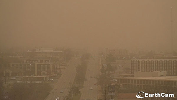
The dust storm’s intensity was compounded by the duration of the wind, which lasted for more than two hours, particularly in the southern Texas Panhandle. Much of the region experienced sustained wind speeds of 50-65 mph on this day, with areas in the northern South Plains and southern Texas Panhandle recording the highest wind gusts between 75-85 mph. The combination of high winds and airborne dust led to numerous road accidents, property damage, and respiratory problems in the communities that were affected. Beyond the dust, the dry and windy conditions prompted the rapid spread of wildfires across the eastern Texas Panhandle and into central Oklahoma. These fires added another level of danger to the already hazardous environment, especially for those forced to evacuate, (1). As of Sunday, March 16th, more than 400 homes were damaged by fires in Oklahoma alone (2), while Red Flag warnings and poor air quality continued across the region for several more days.
Tornado Outbreak Damages Multiple Communities Across the Midwest and South
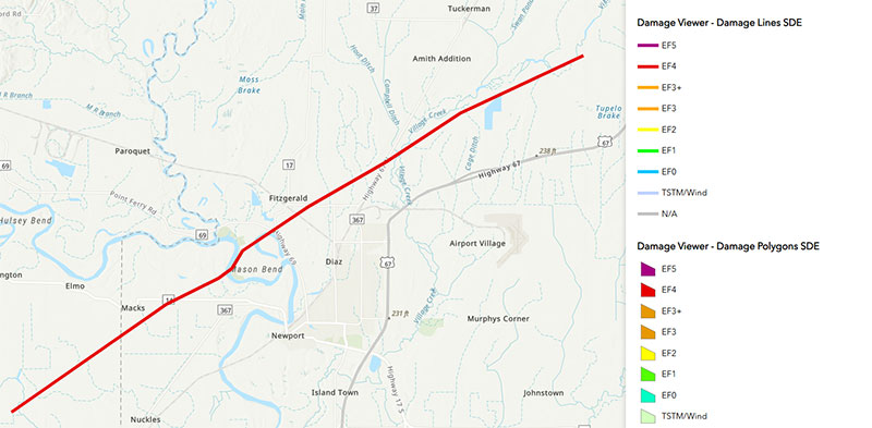
The chaos continued as the cyclone advanced to the east. With tight temperature and pressure gradients ahead of the system, strong southerly winds carried unseasonably warm air into the region (3), destabilizing the atmosphere and promoting the development of severe thunderstorms and tornadoes. The Storm Prediction Center (SPC) issued three Particularly Dangerous Situation (PDS) tornado watches across parts of the Midwest and South, covering a total of nine states. According to preliminary SPC storm reports as of March 27th, the outbreak from March 14th to 16th produced 178 tornado reports, 16 instances of damaging winds at or exceeding 74 MPH, and 16 reports of large hail measuring two inches or more in diameter over the three-day period. The highest preliminary EF rating of this outbreak includes three EF-4 tornadoes, two of which occurred in Arkansas on the night of March 14th: the communities of Larkin and Diaz were threatened by large, violent tornadoes in the dark, with peak winds of 170 MPH and 190 mph, respectively. The next day in Mississippi, the third EF4-rated tornado of this outbreak tore through several counties, including Pike and Walthall where it reached a frightening width of 1400 yards (≈ 0.8 miles). A few hours later an EF-3 tornado touched down near Valley Creek Junction in Dallas County, Alabama, claiming two lives and injuring two more. Eight people were injured in Perquimans County, North Carolina the following day on March 16th when an EF-1 tornado swept through the Longview Estates Mobile Home Park at around 3:00 AM EDT, (4,5).
Final Thoughts
Relief organizations and federal and state emergency agencies have mobilized resources to aid affected communities. Several state governors have declared emergencies, expediting assistance to those in need. As recovery continues, meteorologists and emergency management officials will analyze this event to improve warning systems and disaster preparedness. The early issuance of PDS tornado watches likely saved lives by alerting the public to the severity of the event well in advance, giving communities crucial time to prepare before the storm’s arrival. While assessments of the damage and losses from this event are still ongoing, it marks the beginning of what is typically the most active season for severe storms. With months of heightened extreme weather and tornado activity ahead, residents in at-risk areas need to remain alert, monitor the National Weather Service’s (NWS) SPC webpage and local weather broadcasts for updates, and take warnings seriously when issued. For those of us who feel anxious when severe weather is imminent, visit the NWS’ “Storm Anxiety” resource for expert advice on how to manage and reduce your weather fears.
References
- “Historic wind…” NOAA NWS
- “Wildfire Situation Update 4” Oklahoma Dept. of Emergency Management
- “March 14-15 Severe Weather Recap” NOAA NWS
- “SPC Severe Weather Event Review” NOAA NWS SPC
- “EF-1 tornado confirmed…” WTKR Northeast NC
- “PDS Tornado Watch” NOAA NWS Glossary
- “Storm Anxiety” NOAA NWS
- Figure 1, OKC EarthCam
- Figure 2, Diaz, AR EF-4 Damage Line, NOAA NWS Damage Assessment Toolkit