What is an Atmospheric River?
Published: January 10, 2023
Updated: January 13, 2023
You may have heard the term atmospheric river when you hear about heavy rain or snow events across the western United States. Do you wonder what is an atmospheric river? And why do they cause heavy precipitation? Atmospheric rivers are nothing new, like bomb cyclones and the polar vortex, atmospheric rivers are a phenomenon that have always existed. In recent years, they have come to be better understood and have become referenced frequently in media coverage of inclement weather, especially along the Pacific coast of the United States.
An atmospheric river is just as it sounds, the atmospheric counterpart (water vapor) to a river of water (liquid) moving between two riverbanks. That is, an elongated stream of high water vapor being transported in a narrow stream between an area of lower pressure to the left and an area of higher pressure to the right (in the northern hemisphere). This stream of high water vapor transport is typically along and ahead of cold fronts, which are associated with the area of lower pressure. The American Meteorological Society defines an atmospheric river as “A long, narrow, and transient corridor of strong horizontal water vapor transport that is typically associated with a low-level jet stream ahead of the cold front of an extratropical cyclone”. The intensity of atmospheric rivers varies. Intensity is determined by a combination of the amount of water vapor in the atmosphere (vertically integrated) and the winds transporting the water vapor.
Precipitation within atmospheric rivers occurs when there is rising air within the atmospheric river. Heavy precipitation events occur when atmospheric rivers impinge upon coastlines and mountains, where orographic forcing (air rising over terrain) acts to cool and condense out water vapor as rain and snow. The more perpendicular an atmospheric river intersects a mountain range the more precipitation it produces. Less precipitation occurs when the atmospheric river impacts a mountain range at an angle closer to parallel. Variations in mountain terrain and canyons can still yield localized heavy precipitation even if the atmospheric river does not align perpendicular with the mean axis of highest topography. For example, in a scenario where the atmospheric river moves north and east, southwest facing canyons in a mountain range receive more rainfall and snowfall (vapor transport from southwest to northeast). One ridge over, the adjacent canyon could face northwest and receive lighter amounts of rainfall and snowfall. This variation in precipitation amounts also occurs at different elevations.
Another factor that controls how much precipitation falls during a landfalling atmospheric river is the duration of the atmospheric river. In cases where a storm system stalls out across the Eastern Pacific or there are a series of storm systems that create a very long atmospheric river, high moisture air is transported inland for multiple days. These strong, long duration atmospheric river events often lead to incredible rain and snow amounts across the western U.S. and in particular the Sierra Nevada and Cascade Mountain ranges.
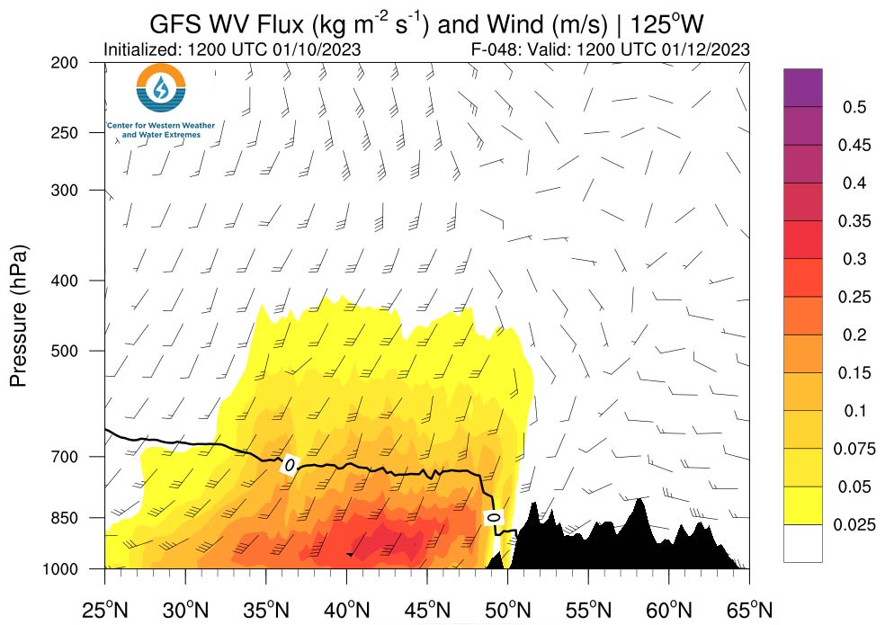
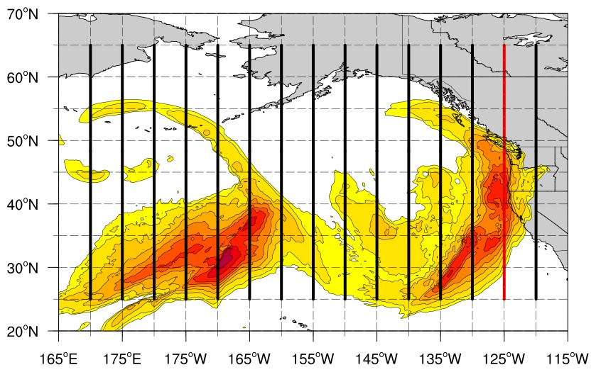
There are several ways to measure atmospheric properties that correspond to an atmospheric river. The most commonly used metric is Integrated Vapor Transport (IVT) which is the integrated product of water vapor multiplied with horizontal winds throughout the troposphere. The units are kilograms per meter second. That is, the amount (mass) of water vapor being transported one meter in one second. A map of IVT from NOAA’s GFS model is shown in figure 1. Figure 1 shows a series atmospheric rivers associated with individual storm systems stretching from the central Pacific ocean to the US west coast. Note that this atmospheric river is made up of several areas of higher transport (darker reds), associated with a series of storm systems. A vertical cross section of this is shown in figure 2 along and just off of the U.S. west coast. Notice how most of the water vapor transport is in the lower part of the atmosphere as southwest winds transport high water vapor content into areas from northern California to Washington, resulting in heavy precipitation.
Thanks to research on atmospheric rivers, we have begun to better understand and appreciate their importance for providing precipitation to midlatitude locations. One recent, seminal study by Ralph et al. (2017) found that on average, atmospheric rivers are 500-600 miles wide and roughly 1,000 miles long but can be much longer. This study found that most of the water vapor is located in the lowest two miles of the atmospheric layer, and that 250 kg m^(-1 ) s^(-1) is a good value for quantifying the boundary of an atmospheric river. But one of the most fascinating facts from Ralph et al. (2017) is that an average atmospheric river transports 2.6 times more water (in the form of water vapor) than the Amazon River discharges! So, the next time you hear of an atmospheric river bringing heavy precipitation, you know it is a layer of high water vapor content being transported by winds at low to mid-levels from more tropical latitudes that cools, condenses, producing heavy precipitation along coastlines and mountain ranges.