Exploring the Mosaic of Mid-Latitude Cyclone Hazards
Published: February 27, 2024
In the United States, those who live north of the subtropics might expect a sort of idleness to accompany the winter season: when the snow conceals the ground and muffles nearly all nearby sound, they find themselves temporarily removed from the turbulence of heat. However, this image of tranquility does not offer protection from severe weather. For others, the transition from fall to winter might alleviate the concern for hurricanes or extreme heat, but different threats follow suit. Every year, severe winter weather calls for preparation when large-scale weather patterns bring a diverse array of hazards across the country.
The Formation and Evolution of Mid-Latitude Cyclones
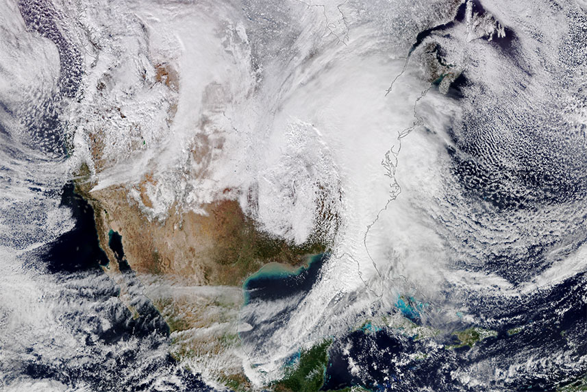
Weather happens on various spatial scales across our planet. A late-evening thunderstorm impacts a county or two, but a sturdy cold front will likely give rise to a chain of storms that traverses a few states. These cold fronts mark the convergence between massive pockets of warm air from the tropics and frigid air from the polar regions. Since cold air is more dense than warm air, the cold air mass forces the warm air mass to rise, leading to precipitation along the frontal boundary [1]. This contrast between different temperatures, and different pressures, within air masses along fronts sets the stage for the formation of mid-latitude cyclones. A mid-latitude cyclone (i.e., extratropical cyclone or wave cyclone) typically begins when an area of low pressure in the upper atmosphere, known as a trough, interacts with a stationary front [2,3]. With the right forces at work, cyclogenesis can occur [4]. Mid-latitude cyclones, stretching over hundreds of miles, are characterized by different stages of their development: they reach their peak intensity when the cold front overpowers the warm front and initiates the mature stage, as seen in Figures 1 and 2 [3].
The Wild Weather Associated with Mid-Latitude Cyclones
Mid-latitude cyclones may have some similarities to their tropical counterparts on satellite and radar (namely a counter-clockwise rotation and precipitation surrounding the low pressure center), but a fundamental difference is their reliance on temperature differences for formation. This allows for diverse weather phenomena to occur within distinct sectors of the mid-latitude storm system throughout its development. If you have ever experienced a named winter storm, then you have encountered a mid-latitude cyclone; likewise if you have endured strong squalls and tornado risk ahead of a cold front.
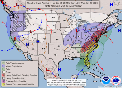
Mid-latitude cyclones can trigger a barrage of seemingly conflicting severe weather alerts that sometimes appear as if the country is experiencing several seasons simultaneously. On January 12, 2024, the National Weather Service (NWS) issued widespread hazard advisories, watches, and warnings as Winter Storm Gerri voyaged from the Northwest, southward across the Midwest, and finally north-northeast to the Great Lakes [6]. The regions in the cold sector, behind the cold front, faced many winter hazards, even reaching rare blizzard conditions in the Northwest; while those in the warm sector, ahead of the cold front, saw some tornado-warned storms and flood advisories [7]. With each color representing a different hazard, the NWS hazards map in Figure 3 showcases the range and assortment of impacts mid-latitude cyclones can provoke throughout their life cycle.
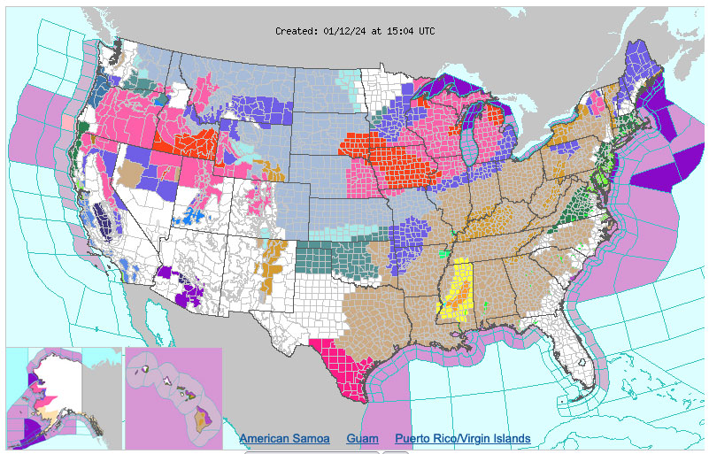
Every single state had a hazard advisory of some sort on this day, from a blizzard warning in Idaho to a flash flood watch in Virginia. Gerri dropped more than two feet of snow in Moline, Illinois, making January 12th their second snowiest day on record [7]. Several southern states including Tennessee, Louisiana, and Mississippi were under a tornado watch by the morning of January 13th as Gerri’s strong cold front approached.
Mid-Latitude Cyclones vs Their Tropical Cousins
When you think of a “cyclone,” does this bizarre medley of weather phenomena usually come to mind? The NWS defines a “cyclone” as “[a] large-scale circulation of winds around a central region of low atmospheric pressure, counterclockwise in the Northern Hemisphere, clockwise in the Southern Hemisphere.” Of course, this refers to tropical cyclones, too [9]. Tropical cyclones are known as “Hurricanes” when they form in the Atlantic Basin, as well as in the Central and Eastern North Pacific basins. They are called “Typhoons”, or simply “Tropical Cyclones,” in other ocean basins around the world [10]. While mid-latitude cyclones can be intense storms, tropical cyclones have the potential to produce even more severe impacts.
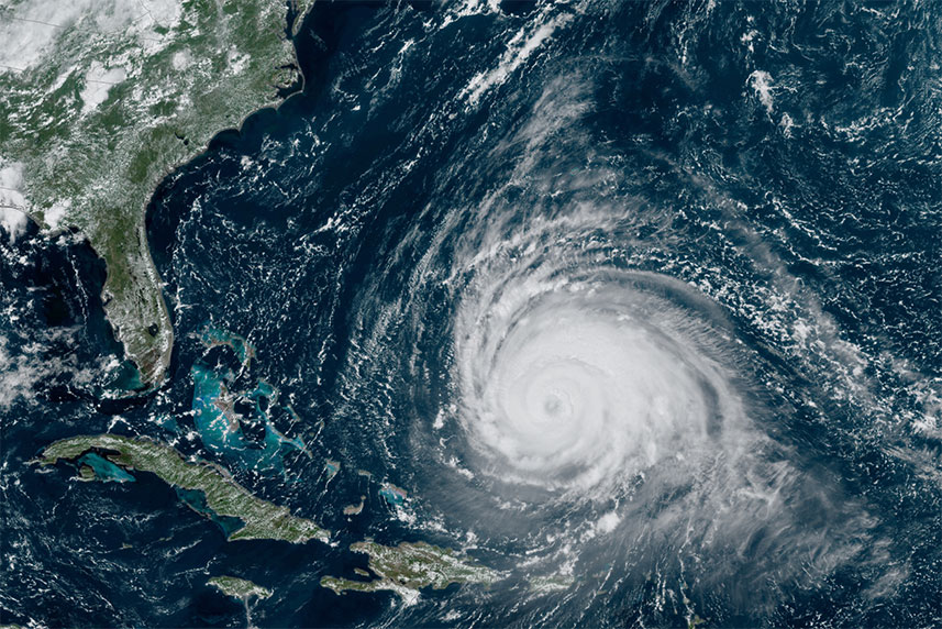
Unlike mid-latitude cyclones, tropical cyclones are characterized by having a warm-core as they primarily form and strengthen by ingesting warm, moist air over the ocean. As that air rises within the convection surrounding the center of the tropical cyclone, it condenses and releases latent heat, which further warms the core of the cyclone. That warm air continues to rise, and as it does so, air rushes in near the surface to replace it, creating the strong winds that are so characteristic of tropical cyclones [12]. The need for warm waters and warm, moist air is why hurricane season runs from the summer through late fall, when sea surface temperatures are at their warmest. As mentioned before, mid-latitude cyclones arise from temperature and pressure differentials between polar and tropical air masses. These differentials are strongest during the winter, which is why wintertime mid-latitude cyclones tend to be stronger than those that form at other times of year [13].
The Hazards Associated with Tropical Cyclones
The primary hazards associated with tropical cyclones are extreme wind, immense rainfall, and storm surge [14]. The most severe impacts of tropical cyclones tend to coincide with where the center, or the eye, of the tropical cyclone makes landfall, although severe wind and especially rainfall impacts can extend far inland. Dangerous storm surges are possible with mid-latitude cyclones, but it's always a concern for coastal communities in the path of a tropical cyclone, because faster wind speeds lead to greater surge heights. There is another key difference between the impacts of these two types of cyclones: a tropical cyclone doesn’t snow! Winter weather of any sort is not a characteristic of tropical cyclones. So, although tropical cyclones may be more intense, they produce less diverse impacts than mid-latitude cyclones, and those impacts tend to be more concentrated. A tropical cyclone may impact several states, but a mid-latitude cyclone can sweep across the entire country!
Closing Thoughts
As we head into the final stretch of winter, the primary hazards of mid-latitude cyclones will shift from winter weather like snow and ice to springtime severe thunderstorms. And when we approach summer, attention will turn to the tropics. There’s never a boring season in meteorology, so stay tuned!
About Talia Cogdill:
Talia Cogdill is an ACM Writing Intern and undergraduate senior at The University of Florida, where she majors in Geography and English. She is dedicated to communicating the complex patterns of Earth's natural hazards and enhancing the resiliency of human and ecological communities to extreme events.
References
- “Air-Masses,” NOAA JetStream
- “Basic Wave Patterns,” NOAA JetStream
- “Norwegian Cyclone Model,” NOAA JetStream
- “Cyclogenesis,” AMS Glossary
- Figure 1, NASA Earth Observatory
- “Winter Storm Gerri Recap,” The Weather Channel
- “Winter Storm Gerri [...]” Weather Underground
- Figure 2, NOAA NWS Hazards Map Legend
- “Cyclone,”NOAA NWS Glossary
- “What is the difference between a hurricane and a typhoon?” NOAA NOS
- Figure 3. NASA Earth Observatory
- “Latent heat,” NOAA NWS Glossary
- “What is the Polar Vortex?” NOAA NWS
- “Hurricanes,”NOAA