April Showers and Supercells: Severe Spring Weather in the Central U.S.
Published: May 29th, 2024
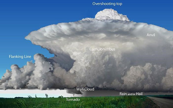
The arrival of spring marks an eager transition from the brief, icy days of winter to the sprouting promise of new growth and a forthcoming summer. For those in the Central U.S., spring also designates the season of seemingly continuous severe weather. This involves hazardous winds, large hail, flash floods, tornadoes, and more. Any state has the potential for tornadoes, but the U.S. Midwest and Great Plains account for 30% of the estimated 1,200 tornadoes that impact the U.S. each year, since the official record began in 1950 (1). A certain type of thunderstorm held responsible for nearly all significant tornadoes in the country, the supercell, occurs most commonly in this region (2). A supercell is a towering, anvil-shaped thunderstorm with a sustained rotating updraft called a mesocyclone (3), which is defined under certain criteria by a rotation signature on doppler radar (4).
Supercell thunderstorm formation in the Central U.S. increases in frequency during the spring when large-scale storm systems arise by converging air masses from the hot and humid Gulf of Mexico and the cool, dry Rocky Mountains. With instability present and a powerful trough in the jet stream to provide wind shear, these rotating storms can flourish— especially along the dryline, where strong density gradients between the humid and dry air masses promote thunderstorm development (5, 6). While not all supercell thunderstorms spawn a tornado, some have produced more than one. The 2024 tornado season in the contiguous U.S. has already claimed second place for the most activity in the month of April, with a preliminary count of 367 tornadoes (7). With the season at its peak until June, we can expect to see more impacts from severe weather in various U.S. regions as we move closer to summer.
April 2024 Severe Weather Outbreaks in the Central U.S.
Tornado activity in the month of March was slightly below average, with a preliminary count of 66 tornadoes (7). As mentioned before, this past April was above average for tornado activity across the contiguous U.S. At the tail-end of April, 130 confirmed tornadoes occurred across the central U.S. in only four days, including an EF-4 rated tornado in Oklahoma and several EF-3 rated tornadoes between Oklahoma, Nebraska and Iowa. On the night of April 27th, the small city of Marietta, Oklahoma sustained intense damage from the first EF-4 rated tornado in the state since 2016; this tornado traveled 27 miles in approximately 24 minutes, with estimated peak winds between 165-175 MPH. Two EF-3 tornadoes impacted the cities of Sulphur and Holdenville, Oklahoma on the same night, and in all, four lives were lost as a result (8).
A day prior, Iowa and Nebraska experienced a severe weather outbreak that produced several long-tracked tornadoes with intensities the area has not seen since 2014. Many homes, businesses, and personal belongings were damaged or lost and several people were injured. A fatality occurred when an EF-3 tornado swept through the eastern side of Minden, Iowa in the evening hours of April 26th. This tornado traveled 40 miles and was nearly a mile wide at its largest. Elkhorn, an Omaha metropolitan neighborhood, experienced an EF3 tornado around 3:30pm CDT that caused extensive property damage but had no reported deaths. The Lincoln area of Nebraska also saw an EF3 tornado on this same day, which traveled from the northeast side of the city to the north of Waverly, severely damaging a manufacturing facility (9). Several more states experienced at least one confirmed tornado between April 25-28, including Wyoming, Texas, Kansas, and Missouri.
Kaj O’Mara is not only a long-time Iowa resident, but an expert meteorologist with years of broadcast and consulting experience, including his current position as Senior Meteorology Consultant at J.S. Held LLC. By the time he decided to step aside from the greenscreen in 2023, O’Mara had diligently covered the 2008 EF-5 tornado that struck Parkersburg and New Hartford and several record-breaking events including a flood, blizzard, and many severe droughts and temperature extremes. However, a meteorologist’s duties continue even after the broadcast ends; during the recent outbreak that spawned destructive tornadoes in Iowa and Nebraska on April 26th, O’Mara closely followed the storms by radar and livestreams, reaching out to family, friends, and clients in the area to ensure they had the information they needed to remain safe.
“From a meteorologist's perspective,” O’Mara says, “you want to get the forecast right, but you hate to see the damage [...] from a dad and human-being perspective, you know people are hurting mentally and physically, and life is so hard as it is, without being hit by a tornado.”
One of the numerous tornadoes in Iowa on this day actually hit O’Mara’s elderly in-laws’ home, which had only sat empty for a short time before this event, after their recent passing. The bond within a community can become reinforced in the wake of destruction: neighborhoods join together for clean up and nearby communities often visit to offer a hand. From an Iowan perspective, O’Mara says “when these tornadoes do happen, Iowans generally show up at the damaged area not to gawk, not to judge, not to offer unsolicited advice, but to ask one question— ‘how can I help?’ ”
May 2024 Issue of “High Risk” for Severe Weather
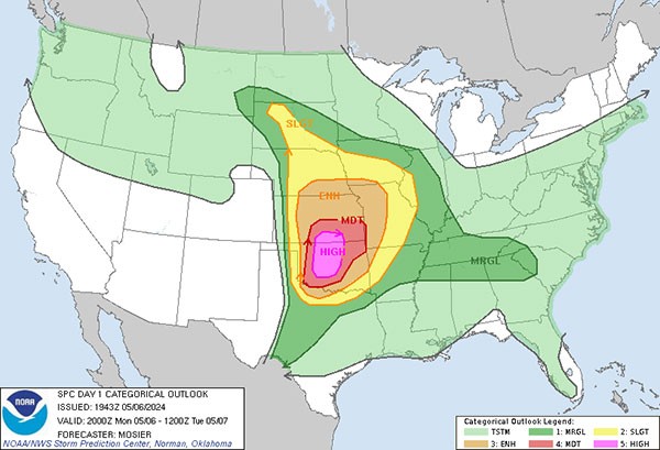
As we continue through May, the month with the highest average frequency of tornadoes in the contiguous U.S., those in the Central U.S. might find themselves inspecting the skies a little more closely. In fact, the first week of May already saw the National Weather Service Storm Prediction Center (NWS SPC) issue a rare High Risk severe storm threat across central and northern Oklahoma and into south-central Kansas. May 6th became the first high-risk severe weather day of 2024 as a strong mid-level trough moved through, providing an exceptional environment for heavy rainfall, extreme winds, very big hail, and tornadogenesis. Multiple long-tracked EF3+ tornadoes were expected within this area of high risk. Fortunately, the event itself did not become a widespread worst case scenario, however multiple destructive tornadoes did occur. Barnsdall and Bartlesville, Oklahoma, fell within the polygon of a Tornado Emergency (10) while both cities sustained significant damage from a large tornado on that Monday night.
It’s vital to keep in mind that severe weather involves much more than tornado potential. On May 6th, the SPC received 393 preliminary hail reports, with 13 being at least two inches in diameter, and several reports of hail up to four inches in parts of Oklahoma and Kansas (12). While perhaps not as daunting as a tornado, hail tends to destroy crops, damage roofs, and create hazardous road conditions by shattering windshields and sometimes melting into a flood threat. Straight-line winds also contributed to the overall severe threat on this day: several large trees, fences, and roofs were toppled or significantly damaged. Osage and Muskogee counties in Oklahoma experienced wind speeds estimated at 75 MPH (12), just within the threshold of hurricane strength.
Closing Thoughts
Spring in the Central U.S. keeps many residents busy, from prepping homes and storm shelters to frequently checking the radar or tuning into local broadcasts. Although the Central U.S. accounts for the majority of tornadoes recorded each year in the country, “tornado season” really depends on where and when: the risk for severe weather in the southern Great Plains tends to relax a little as summer takes over, passing this risk on to the upper Plains, Midwest, and Dixie Alley starting June, until the primary focus shifts to the Southeast in the late winter (13). Of course, this does not mean severe weather outbreaks can only happen during their designated seasons. Understanding the climatology of severe weather can help many prepare for the worst; with a steady focus on the forecast year-round, we can become weather wise, and avoid finding ourselves blindsided by hazardous events. In other words— keep watching the skies!
References
- ““Thunderstorm Hazards - Tornadoes” NOAA JetStream
- “Types of Thunderstorms - Supercells” NOAA JetStream
- “What is a Supercell?” NOAA NWS
- “Mesocyclone” NOAA NWS Glossary
- “Why April, May and June are Most Active…” The Weather Channel
- “Dryline” NOAA NWS Glossary
- “U.S. Tornadoes” NOAA NCEI
- “April 27-28 Tornado Outbreak…” NOAA NWS
- “Tornado Outbreak of April 26, 2024” NOAA NWS
- “Tornado Emergency” NOAA NWS Glossary
- “MAY 6, 2024 - Day 1 Convective Outlook” NOAA SPC
- “MAY 6, 2024 - Severe Weather Event Review” NOAA SPC
- “Severe Weather Climatology” NOAA SPC