Weather Experts at the Association of Certified Meteorologists Discuss Hurricane Ian
Published: November, 11, 2022
Hurricane Ian was the third major hurricane to make landfall in Florida in the past five years and the second of such hurricanes in recent years to strike southwest Florida – the other being Hurricane Irma in 2017. A major hurricane is a tropical cyclone in which Category 3 strength or greater is achieved. On September 28, 2022, Hurricane Ian made landfall along coastal Lee and Charlotte Counties in southwest Florida at high-end Category-4 strength.
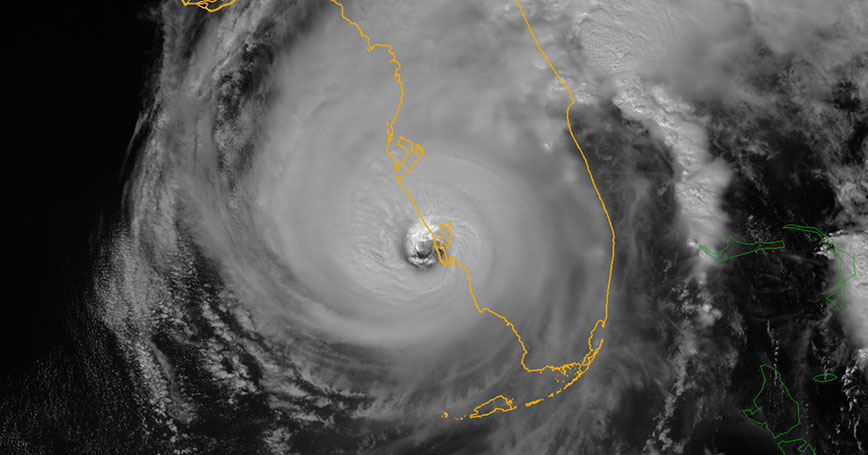
Numerous weather sensors in the area of landfall recorded surface wind gusts in excess of 100 miles per hour, while storm surge and flood gauges indicated water levels rising to at and above one-story levels in some coastal, flood-and-surge-prone areas.
According to the National Centers of Environmental Information, as of October 31, 2022, Ian was responsible for 131 fatalities. John Lavin, Certified Consulting Meteorologist, ACM Member, and Director of Forensic Services at AccuWeather explained, “Ian is likely the deadliest tropical system for the state of Florida since the 1935 Labor Day Hurricane, which killed over 400 people.”
While damage cost estimates have varied widely in the aftermath of Hurricane Ian, most estimates put Hurricane Ian in the top-5 of costliest tropical cyclones (not adjusted for inflation) in the mainland United States (according to NOAA), perhaps as high as Hurricane Harvey (2017) and Hurricane Katrina (2005), or at least near to that of Hurricane Sandy (2012) and Hurricane Ida (2021).
Meteorologists from the Association of Certified Meteorologists (ACM) have been tracking Hurricane Ian and its aftermath since the storm first originated near the Windward Islands in the Caribbean. H. Michael Mogil, ACM member and Certified Consulting Meteorologist with How The WeatherWorks out of Naples, Florida – just south of the landfall location of Hurricane Ian - conducted live broadcasts with Dave Elliott’s Morning Talk Show (WGUF-FM) regarding the storm, and discussed Hurricane Ian’s impacts and attributes with many local residents. “Many residents…noted several things. First, how fast the water rose. This wasn't surprising, because before the storm arrived, winds with a component from the east were blowing water offshore. As the winds started to turn to onshore, the storm surge was more easily added to the water shortfall at the shoreline. Of course, once the water started to rise quickly, escape for coastal and waterway residents who opted to stay in their homes became impossible.”
According to Mr. Mogil, the water levels rose in Naples by about two feet per hour during the onset of Ian’s surge. “Dave Elliott and I also discussed the coastal shape in and near Fort Myers Beach and Sanibel Island and how this concave-shaped coastal region was primed for the surge along with the horizontal squeeze (and vertical rise) that the coastal shape would provide. I believe we referred to that region as ‘ground zero.’”
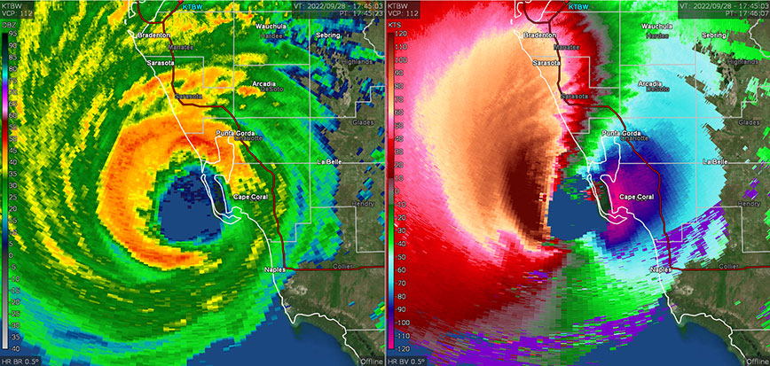
Now, as the state recovers, the insurance claim and rebuilding processes are underway. At the same time, professional meteorologists are also reviewing all of the weather data from the storm. “While the National Hurricane Center warns for a hurricane to be a certain magnitude and follow a certain track, the real truth of the actual magnitude, especially on land-surface and the impacts of the storm, often take months following the hurricane to decipher and understand,” according to Dan Schreiber, Certified Consulting Meteorologist and ACM Member based in Texas with STWX Strategic. “For example, Hurricane Michael in 2018 was believed to be a Category-4 hurricane at landfall, but after further analysis months later, was upgraded to Category-5. There is a lot of misinformation and speculation ongoing regarding Hurricane Ian’s magnitude, but at this point, Hurricane Ian is still officially on the record as a Category-4 storm, and the highest measured wind gust on land currently published – on a preliminary basis - by the National Weather Service at a single location is 140 MPH.”
Mr. T.C. Moore, Certified Consulting Meteorologist, ACM Member, and owner of Atlantic States Weather in Raleigh, North Carolina further elaborated, stating: “The National Hurricane Center Tropical Cyclone Report usually contains an exhaustive analysis of the post-storm calculations used in setting the maximum sustained winds at landfall. However, many factors impact whether any location, even on the immediate coast, will see winds up to the maximum estimated by the NHC…which are usually contained in a very small area of the storm.” Mr. Moore also indicated that there are unpublished studies that point toward maximum wind gusts on land being about the same, or slightly less, than the estimated maximum sustained winds of the hurricane, often due to increased surface friction over land. “When hurricane winds move over land, increased friction begins to slow down the winds near the surface. This is especially true in wooded areas and in areas with a concentration of man-made structures.”
With most data from Hurricane Ian is still considered preliminary, and even in some cases possibly erroneous, certified meteorologists are in high demand as the Florida insurance market grapples with significant losses as a result of the storm – from winds, floods, and surge to tornadic activity. According to Megan Walker, Certified Consulting Meteorologist and ACM member at Blue Skies Meteorological Services in Gainesville, Florida, “It's always important to work with a credentialed meteorologist, but especially so when utilizing preliminary data…to construct a consistent, scientifically rigorous picture of conditions on the ground. Failing to do so, and building opinions on questionable data, can lead to incorrect conclusions, with potentially significant consequences for the [end user].”
One important meteorological fact regarding Hurricane Ian – like all hurricanes – is that weather conditions in one location may be significantly different than other locations impacted by the same storm. Mr. Moore further noted that even the altitude of measured wind reports need to be carefully examined, as elevated wind measurements may be significantly different than near-ground wind measurements.
ACM Member Jay Rosenthal, a Certified Consulting Meteorologist at Air, Weather & Sea Conditions, Inc. based in California explained his thoughts on Hurricane Ian: “What I think is worth noting about Hurricane Ian is that storm surge at any one location is very dependent on distance and direction from the eye. It makes a big difference if you are in the sector where winds blow towards the coast versus away from the coast, and that can vary greatly over a relatively short distance, as was observed with Ian.”
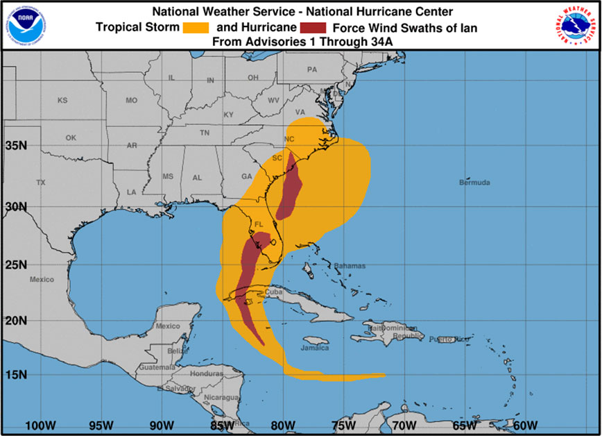
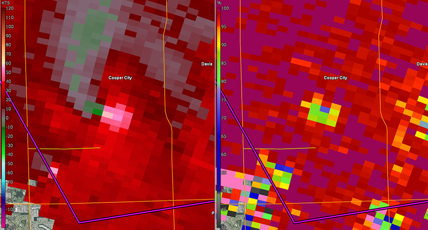
Aside from storm surge, the highest winds generally associated with hurricanes are found within the eyewall of the storm. Therefore, while the storm itself did produce measured surface wind gusts in excess of 100 MPH in some places in southwest Florida, this does not hold true for the entirety of Florida. For example, the Miami-Fort Lauderdale-Palm Beach metroplex largely sustained only tropical-storm force winds, but did encounter a handful of damaging tornadoes.
Dr. Matthew Bunkers, Certified Consulting Meteorologist and ACM Member with Northern Plains Weather Services in Rapid City, South Dakota provided some expertise on this tornadic activity, stating, “The thunderstorms that produced these tornadoes were smaller than the typical tornadic storms in the central United States; however, some of them had clear velocity signatures suggestive of a tornado, along with a ‘tornadic debris signature’ - revealed by the dual-polarization radar’s ability to detect non-weather targets. Tornadoes such as these are typically found in the right-front quadrant of a hurricane.”
Impacts of Hurricane Ian were felt far from the south Florida as well, with high winds and copious rainfall across central Florida and along the Space Coast. Some of these impacts were accomplished as Ian was officially at only Tropical-Storm strength while it crossed the Florida peninsula before regaining Category-1 strength in the warm Gulf Stream waters of the Atlantic Ocean offshore of northeast Florida.
Hurricane Ian then made landfall again near Georgetown, South Carolina, and eventually travelled into North Carolina as a Tropical Storm, with many hybrid, mid-latitude storm characteristics. According to Mr. Moore, in North Carolina, “Among the 45 weather stations in the North Carolina State Climate Office ECONet, 19 [stations] recorded tropical storm-force gusts of at least 39 mph.” Additionally, “A wind-driven storm surge reached up to 5 feet high on the Cape Fear River in Wilmington, North Carolina. That was the fifth-highest level on record at that gauge, behind the crests from some of the state’s most infamous hurricanes – Isaias, Florence, Matthew, and Hazel.”
In addition to scientific hurricane analysis, Certified Consulting Meteorologists are also crucial in the research, discovery, and implementation of new emergency management techniques and partnerships related to severe weather, like hurricanes. Mr. Jay Rosenthal elaborated: “In spite of all the efforts by NOAA and the emergency response agencies, there will always be a certain percentage of people that choose to not evacuate [a hurricane]. That's just the way it is, and it probably would be beneficial to develop and implement strategies in emergency response that account for this segment of the population.”
Hurricane Ian’s forecasted center-track did fluctuate as the storm approached, initially centering over southwest Florida, then shifting slightly west more parallel to the coastline, then back east toward southwest Florida as the forecast was refined. This drew some criticism to forecasters, emergency planners, and politicians alike.
Some meteorologists argue that much of this confusion and lack of certainty by the greater public was due to the improper interpretations of Hurricane Ian’s forecast “cone” by the end-users. Mr. Mogil explained, “In talking with some people from Naples to near Fort Myers, I also learned just how closely people [follow] the ‘cone’ and spaghetti plots. Contrary to all advice, they tend to view the storm as a point and as impacts limited to the cone. The various watch-warning graphics by NWS, NHC, TV stations, and private meteorologists seem lost in the focus on the ‘cone.’”
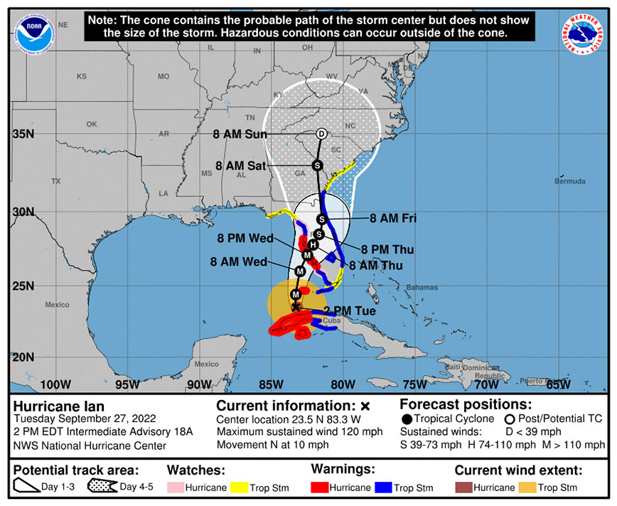
Craig Setzer, tropical meteorologist and ACM associate member with Setzer Weather in Broward County, Florida, has written extensively about the interpretation of hurricane forecasts and much of the confusion that they bring. Citing literature published in the Bulletin of the American Meteorological Society (BAMS), Mr. Setzer reiterated that prior to Hurricane Ian, nearly 50% of surveyed Florida residents believed that the generic tropical cyclone forecast “cone” represented the extent of the storm. Instead, as Mr. Setzer states, “The cone does not represent anything other than future points on a map within a probabilistic interval… where the forecast center point of a storm is expected to be two-thirds of the time based on the National Hurricane Center’s previous five-year forecast skill.”
Mr. Setzer explains that the public relies heavily on the “cone” to plan and prepare for a tropical cyclone, like a hurricane, so much so that they believe that the “cone” is the storm, and this could lead to life-threatening mistakes. “We’ve had 20 years of testing the NHC forecast cone, and still the public largely misses the message from that graphical tool. The cone is doing what the cone is supposed to do. It is tracking where a point on a map is expected to be two-thirds of the time. But a tropical storm or hurricane is much bigger than a one-dimensional point on a map, and the graphical tools we use to warn people should indicate it as such.”
Mr. Mogil further elaborated, “There are some significant educational issues linked to this. Even with TV station hurricane guides and TV meteorologists providing outstanding coverage leading up, during, and following storm events, and public and community meetings focusing on preparedness and response, students (grades K-12) are receiving limited education in meteorology, in general, and in severe weather, in particular.”
In the wake of Hurricane Ian, one consistent question asked of meteorologists regards climate change and its relationship to hurricanes. While in recent years there have been several major hurricanes making landfall on the Atlantic and Gulf coasts, the relation to climate change is still to be determined. The American Meteorological Society stated in their 2019 Climate Change Statement, “The number and intensity of Atlantic hurricanes have both increased since the early 1980s, but much of this increase may be due to natural variability of the atmosphere and ocean. Furthermore, there is little trend or even a decrease in hurricane activity in other ocean basins, so the global trend, if there is one, is not clear. There is evidence that ocean warming is providing more energy to make hurricanes more intense.”
Despite no clear global trend between climate change and increased tropical cyclone activity, tropical storms and hurricanes remain a huge threat to coastal areas across the globe. Mr. Rosenthal stated that “It is not generally known that the northeast Pacific Ocean off the coast of Mexico is actually the world's second most prolific area for tropical cyclone development. But since they generally move away from land, they get less attention.”
The 2022 hurricane season has been eventful, and in some ways unique. Hurricane Ian aside, Hurricane Agatha in the Pacific Ocean made landfall in Mexico and the remnants eventually regained tropical storm strength in the Atlantic Ocean (after hitting Florida as an unnamed storm), becoming Tropical Storm Alex. In opposite fashion, Tropical Storm Bonnie in the Caribbean crossed Central America and became Hurricane Bonnie in the Pacific Ocean. Hurricane Julia also crossed Central America and was downgraded to a Tropical Storm in the Pacific, officially making two “cross-over” named-storms - and arguably a third, albeit officially unnamed - in one season.
Also, this season, Hurricane Kay brought tropical storm to hurricane-force wind gusts and heavy rains to parts of southern California, which is a generally rare occurrence at such magnitude.
Even the high latitudes and arctic were not safe from hurricane-related activity this year, with remnants of Typhoon Merbok – as an extratropical cyclone - leading to tropical-storm to typhoon (hurricane)-force winds and significant coastal flooding in western Alaska, including along the Bering Sea, before dissipating completely in the Arctic Ocean. Shortly after, Hurricane Fiona blasted communities along Canada’s Atlantic coast before morphing into an extratropical cyclone and emerging into the Labrador Sea west of Greenland and dissipating at about the same time Hurricane Ian was moving toward southwest Florida.
With the 2022 hurricane season soon coming to a close, rebuilding has just begun. The insurance claim process has a long road ahead. Building regulations, preparedness measures, and emergency response plans will be reviewed. Hurricane Ian will be analyzed, reviewed, investigated, and researched for many years. Meteorologists of the Association of Certified Meteorologists will continue to be at the forefront of many of these initiatives.